Today, June 21, is World Hydrography Day. Hydrographic offices in over 80 maritime nations observe this day every year, since 2005. It is our special day to tell the public what hydrography is, and how it is employed to make navigation safer. Simply, hydrography is the science we use to obtain the data needed to create nautical charts. NOAA’s 200-year history is proof positive that those charts – and therefore hydrography – are a national investment that pays off daily with navigation safety, efficiency, and coastal protection from accidents at sea.
But today’s observation of World Hydrography Day is more profound. It is personal to every person who works in or supports hydrography in the United States.
Continue reading “NOAA observes World Hydrography Day by honoring lost crew members of the Robert J. Walker”
A picture is worth a thousand words – about updating Alaska charts
In late May, NOAA Ship Rainier officially started her Chatham Strait hydrographic survey project in southeast Alaska. It’s often difficult to imagine the age of many of the depth measurements depicted on Alaskan charts, but this short animation brings it home.
The older picture is U.S. Coast and Geodetic Survey Steamer Patterson and her steam-powered launch Cosmos, surveying Gut Bay in 1897. (The USC&GS is one of NOAA’s predecessor agencies, and a direct predecessor of the Office of Coast Survey.) We juxtaposed Patterson with the Rainier, who is finally able to update the bathymetry — at the exact same location — 116 years later.
Continue reading “A picture is worth a thousand words – about updating Alaska charts”
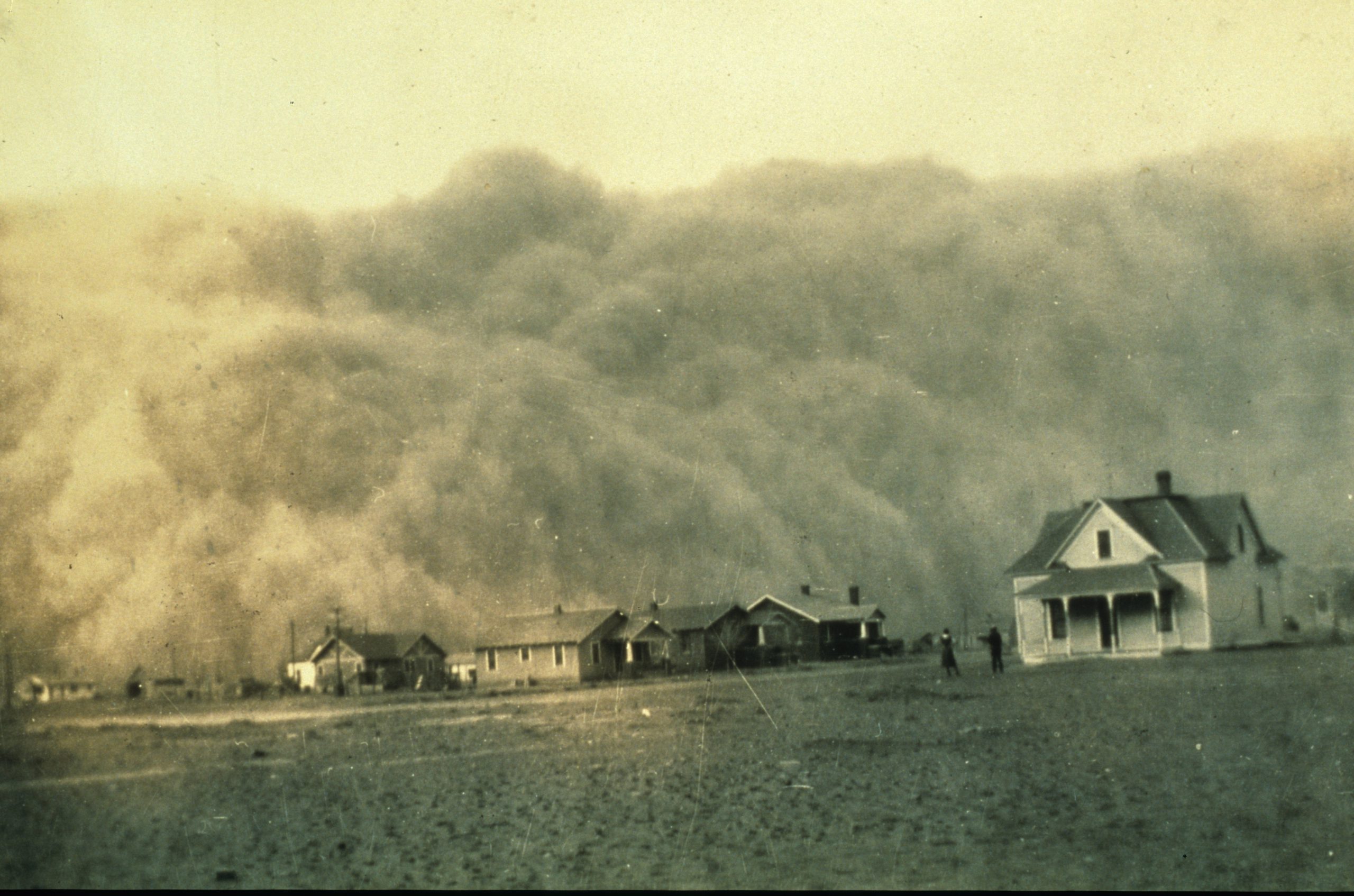
NOAA library blows the dust off a photo of dust clouds
By Linda Joy, NOAA Communications and External Affairs
In April 1935, George Marsh, an unassuming engineer employed by the U.S. Coast and Geodetic Survey, took a photo in the course of his work during a Texas surveying mission. Not having Facebook or other social media tools at hand, he put the photo in an album and stored it away. He could not have known that many decades later, thanks to the NOAA Library and the Internet, his photo would eventually reach millions of people around the globe.
The now famous photo captured boiling dust clouds about to swallow a homestead during the Dust Bowl’s infamous Black Sunday storm.
Continue reading “NOAA library blows the dust off a photo of dust clouds”
A nation pays final tribute to Civil War sailors interred at Arlington National Cemetery
Last week we blogged about the Civil War sailors whose remains were being interred at Arlington National Cemetery on March 8. The funeral, for unknown sailors who were lost when the USS Monitor capsized, was solemn and stirring, and reflected the nation’s great esteem for our fallen patriots. The unknown sailors were lost along with 14 of their shipmates when Monitor sank off Cape Hatteras, N.C., on Dec. 31, 1862.
All 16 sailors will be memorialized on a group marker in section 46 of the cemetery, which is between the amphitheater and the USS Maine Mast memorial.
Rear Admiral Gerd Glang, Coast Survey’s director, was honored to represent NOAA in the officer escort for the caissons. Glang and Rear Admiral Anthony Kurta (USN) served as Escort Commanders, and were joined by Capt. Gary Clore (Navy Chaplain) and Cmdr. Nathaniel Standquist (U.S. Navy Ceremonial Guard), as the nation paid a final tribute.
Continue reading “A nation pays final tribute to Civil War sailors interred at Arlington National Cemetery”
NOAA Coast Survey director to escort caissons for USS Monitor sailors’ interment at Arlington
On Friday, March 8, a NOAA Corps admiral will have the honor of doing something extraordinary. Coast Survey’s director, Rear Admiral Gerd Glang, will be the NOAA Escort Flag Officer for the full honors funeral of two unknown sailors who went down with the Civil War ironclad USS Monitor in 1862. Rear Adm. Glang will join Rear Adm. Anthony Kurta, U.S. Navy, as the two officers escort the caissons during the somber event at Arlington National Cemetery.
The interment will be open to the public.

The Monitor sank southeast of Cape Hatteras, North Carolina, during a New Year’s Eve storm, carrying 16 crew members to their deaths.
The wreck was discovered in 1973, and confirmed in 1974 by John Newton and a team from Duke University. The ironclad was lying upside down with the turret separated from the hull, resting in 230 feet of water approximately 16 miles off Cape Hatteras. In the late 1990s through 2002, experts recovered iconic Monitor artifacts, which are now conserved at the Mariners’ Museum in Newport News, Virginia. Two skeletons were discovered in 2002 when the turret was raised from the seafloor, and efforts to identify the remains have been unsuccessful so far.
Continue reading “NOAA Coast Survey director to escort caissons for USS Monitor sailors’ interment at Arlington”
New (terrific) movie “Lincoln” showcases U.S. Coast Survey Civil War maps
As the scientific federal office that has provided the nation’s navigational charts and services for two centuries, we probably shouldn’t offer (strictly personal) reviews of the (absolutely phenomenal and deeply moving) movie, “Lincoln.” However, after seeing the movie this weekend, we would be remiss if we failed to note the (gorgeous) set designs that show the walls of the White House Cabinet Room and war offices covered with U.S. Coast Survey maps.
Especially prominent, over the shoulder of (marvelous) actor Daniel Day-Lewis, playing the (brilliant and compassionate) Lincoln, was the slave density map that influenced public opinion in the North and guided many of Lincoln’s military decisions, and the map of the State of Virginia.
Those maps, and hundreds more, can be explored in the special historical collection of maps, charts, and documents prepared by the U.S. Coast Survey during the war years. The collection, “Charting a More Perfect Union,” contains over 400 documents and is available free to the public.
Continue reading “New (terrific) movie “Lincoln” showcases U.S. Coast Survey Civil War maps”
The quiet history of Coast Survey
As NOAA strives to meet the present and future navigational needs of the maritime transportation system, it is sometimes helpful ‒ not to mention inspirational ‒ to look back at history. Coast Survey has an amazing history that isn’t well known. It is a quiet history of men and women who led the country’s mapping and charting advancements in the centuries since Thomas Jefferson authorized the Survey of the Coast in 1807.
Coast Survey maintains a publicly accessible Historical Maps and Charts Collection, with about 35,000 images that anyone can download and print. For history buffs, searching through the images is a great way to find images related to your area of interest. Exploring the charts, one can almost develop personal relationships with the individual Coast Survey assistants and cartographers who produced some truly beautiful work. (Check out the Civil War Special Collection to find some especially intriguing maps, including the pivotal 1861 map showing the density of slave population in the Southern states.) Or you can spend some quality time browsing through little-known sketches and maps in the historical collection maintained by the NOAA Central Library.
Continue reading “The quiet history of Coast Survey”
The United States Coast Pilot, with one of the Nation’s longest publishing records, gets better with age
 The United States Coast Pilot®, originally called the American Coast Pilot, has been published for over 200 years. This set of sailing directions for U.S. coastal waters has kept millions of mariners safe from perils at sea. Last week, NOAA’s Office of Coast Survey unveiled yet another improvement to the nine-volume set geared to modern mariners who need updated information as soon as it becomes available.
Anyone can now access PDF versions of the United States Coast Pilot that are updated weekly. The volumes, and the list of corrections or updates applied each week, are available for free on the NOAA Coast Survey website. For those who don’t want to print corrected pages (or the entire volume!) on their home printer, the most up-to-date volumes are also available as Print-on-Demand products from some commercial vendors. (The traditionalists among us will still be able to purchase the hard copy printed annually.)
Continue reading “The United States Coast Pilot, with one of the Nation’s longest publishing records, gets better with age”
Finding WWII wrecks at sea, now and then

How do ocean explorers know where to look when they investigate and document the historical secrets of the deep? Well, archaeological expeditions use a myriad of modern surveying technologies. Recently, when NOAA’s Monitor National Marine Sanctuary was investigating a World War II underwater battlefield site, they called on a surveying expert with NOAA’s Coast Survey to assist.
Continue reading “Finding WWII wrecks at sea, now and then”