Spring is always a noteworthy time at Coast Survey, as the hydrographic season gets underway. This year is no exception, with some neat projects ahead.
On the East Coast, NOAA Ship Thomas Jefferson continues her work with the multi-state, multi-agency Long Island Sound Seafloor Mapping Initiative, as well as acquiring data over 87 square nautical miles in the approaches to New York to update nautical charts. In June, Thomas Jefferson begins some of her summer-long extensive 2013 post-Sandy surveys in Delaware Bay (supported by Title X, Chapter 2, of H.R. 152, the Disaster Relief Appropriations Act, 2013).
As our newest survey vessel, NOAA Ship Ferdinand Hassler, prepares for a long survey career, the crew is taking her through final repairs, upgrades, training, and inspection this spring. If all goes well, Hassler will then survey approaches to Chesapeake Bay in July, before heading to her new homeport in New Castle, New Hampshire. Once there, Hassler plans to survey approaches to New Hampshire and conduct some tests and evaluations of a new autonomous underwater vehicle (AUV) for surveying.
Continue reading “NOAA hydro survey season underway”
NOAA starts 2013 post-Sandy surveys at Statue of Liberty
NOAA kicked off its spring season for post-Sandy hydrographic work on April 11, as a navigation response team — equipped with high-tech surveying equipment — began a search for underwater storm debris and mapped the depths surrounding Liberty Island and Ellis Island. Navigation Response Team 5 wrapped up their project today, after surveying over 110 linear nautical miles. They surveyed for 119 hours, collecting over 578 million depth measurements.
In addition to surveying around Liberty Island and Ellis Island, Coast Survey’s NRT5 surveyed adjacent areas to acquire data for updates to NOAA’s nautical charts. This is the “rainbow” coverage map that shows the surveyed area. (The colors indicate depth.)

Continue reading “NOAA starts 2013 post-Sandy surveys at Statue of Liberty”
Coast Survey supports inauguration preparations
It was an honor to assist with preparations for the Presidential Inaugural. Our assistance, provided before the event, was a combined effort by one of our navigation response teams, survey technicians, cartographers, and several NOAA officers. Coast Survey’s work was additionally supported by colleagues at NOAA’s Center for Operational Oceanographic Products and Services.

For more about navigational planning for the Potomac River, see Coast Guard to establish security zone for the presidential inauguration.
Surveys for Maine fishing community buttress new energy technology
By David McIntire, survey technician, Coast Survey Navigation Response Team 4
Down East Maine. For many, this conjures up imagery of rugged, fog-enshrouded coastline carved for centuries by relentless waves and violent nor’easters, where quaint fishing villages and misty lighthouses hug the shoreline, inhabited by hardy mariners who for generations have braved fierce storms and unimaginable winters to make a living where land and sea meet in perhaps the most spectacular way. Yet this is only part of the story where a nostalgic past embraces an innovative future. Eastport, Maine is no exception and NOAA’s Office of Coast Survey is proud to partner in that endeavor.
Fishing has been the lifeblood of Eastport’s economy for generations and, despite the influx of tourism in recent decades, many Down East families still derive their income from the sea. This may sound quaint and romantic, until you realize that the Bay of Fundy is not the idyllic, placid water of postcards and paintings. With tides ranging nearly 30 feet every few hours, inlets become rife with ripping currents as the back bays fill and empty through these narrow, rocky channels. It is within this treacherous environment that the local commercial fishermen risk their lives – and, over the past decade, a number of them have paid the ultimate price.
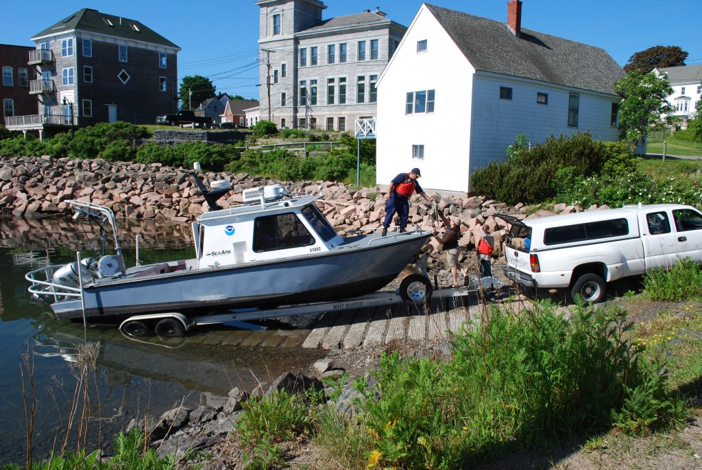
Continue reading “Surveys for Maine fishing community buttress new energy technology”
NOAA’s navigation assets complete primary post-Sandy assignments, remain available to assist
NOAA continues to work in partnership with other federal, state, and local partners in response to the devastation of Hurricane Sandy. NOAA’s efforts are focused on navigation surveys to restore maritime commerce; aerial surveys to assist in those efforts and to aid on-the-ground responders from FEMA and local authorities; and in oil spill cleanup and damage assessment. NOAA’s National Weather Service is also keeping authorities aware of changing weather conditions that could impact recovery and response efforts.
NOAA’s hydrographic survey vessels, including two three-person navigation response teams (NRTs) and the NOAA Ship Thomas Jefferson with her two survey launches, have completed surveys of the Port of New York and New Jersey. Working over the past five days, the high-tech vessels searched approximately 20 square nautical miles of shipping lanes, channels, and terminals to search for dangers to navigation.

Continue reading “NOAA’s navigation assets complete primary post-Sandy assignments, remain available to assist”
Surveys continue in Port of New York / New Jersey, completed in Virginia
Coast Survey’s major survey operations in response to Sandy are completed in Port of Virginia, allowing port operations to resume. That timely resumption is proving to be vital for East Coast shipping, as the port is now receiving cargo diverted from the Port of New York and New Jersey. Associated Press is reporting that more than a thousand containers were offloaded in Virginia yesterday, with more on the way.
Meanwhile, critical survey work continues in the Port of New York and New Jersey, with two of Coast Survey’s navigation response teams (NRT) and two of the Thomas Jefferson launches continuing their search for dangers to navigation in shipping channels and terminals. Today, the high tech survey boats attached to the Thomas Jefferson surveyed the East River, as the ship processes data for delivery to the Coast Guard. One of the boats then went to survey Church Hill Channel this afternoon, while the other went to Gravesend Bay. NRT 2 is surveying Port Elizabeth and Port Newark in Newark Bay. NRT 5 surveyed Kill Van Kull and then proceeded to Author Kill.
Continue reading “Surveys continue in Port of New York / New Jersey, completed in Virginia”
Thomas Jefferson night work gives go-ahead for fuel barge delivery into New York – New Jersey

Even before Sandy hit the New Jersey shore, NOAA’s Office of Coast Survey was mobilizing to respond to the emergency, preparing vessels, personnel, and equipment to conduct hydrographic surveys of hard-hit areas, searching for the underwater debris and shoaling that can paralyze shipping at the nation’s ports.
Continue reading “Thomas Jefferson night work gives go-ahead for fuel barge delivery into New York – New Jersey”
Post-SANDY navigation response in full swing
NOAA’s navigation response teams and other survey assets are in the water (or soon will be) as they respond to SANDY’s destruction, checking for underwater debris and shoaling that may pose a risk to navigation. Tasked by the U.S. Coast Guard Captains of the Port, NOAA vessels can use multibeam echo sounders or side scan sonar, as conditions warrant, to search for the answers that speed resumption of shipping and other vessel movements.
Continue reading “Post-SANDY navigation response in full swing”
NOAA deploys personnel and survey assets to speed resumption of shipping after Sandy – Update 29 Oct

As conditions go downhill, NOAA is deploying personnel and hydrographic survey assets to help speed the resumption of shipping after SANDY clears out.
Coast Survey has deployed navigation managers from outside Hurricane Sandy’s areas of impact, supplemented with headquarters personnel, moving them to areas expected to be hit hard. Navigation managers are now at U.S. Coast Guard Incident Command Centers for New York – New Jersey and for Delaware Bay. We are also working with Coast Guard Captains of the Port for Virginia, Baltimore, and New England. NOAA’s navigation managers are working with the Coast Guard and the Army Corps of Engineers to coordinate deployment of NOAA’s navigation response teams (NRT) for rapid maritime response. They are also identifying vessels of opportunity, for potential use with Coast Survey’s mobile survey team (MIST).
Continue reading “NOAA deploys personnel and survey assets to speed resumption of shipping after Sandy – Update 29 Oct”
NOAA pre-positions survey assets for SANDY maritime response

As Hurricane SANDY heads north along the Atlantic coast, NOAA’s Office of Coast Survey is deep into preparations for maritime rapid response. Two objectives stand out: move navigation response personnel and assets into position to move quickly once SANDY moves out; and batten down survey vessels, to protect them from storm damage.
Coast Survey regularly responds to requests for quick navigation surveys after storms and other damaging events, pulling vessels from their normal survey schedules and deploying them to ports that need hydrographic surveys before they can resume full-fledged shipping.
Continue reading “NOAA pre-positions survey assets for SANDY maritime response”