“Ordinary people, called on to do the extraordinary” in the search for TWA Flight #800

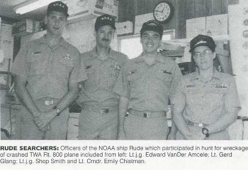
On this date in 1996, twenty years ago, the crew of NOAA Ship Rude completed her special mission and headed back to regular survey duties. Throughout the previous two weeks, Rude’s officers and crew were pivotal in finding the wreckage of – and helping to bring closure to – one of the worst aviation disasters in U.S. history.
From a 1996 report by then-Cmdr. Nick Perugini, NOAA’s Office of Coast Survey, we have this description:

“When TWA Flight 800 exploded out of the sky this summer, NOAA hydrographic survey vessel Rude began a dramatic journey which would test to the limit skills and resources of its officers and crew, and bring to national attention the agency’s hydrographic capabilities.

Continue reading ““Ordinary people, called on to do the extraordinary” in the search for TWA Flight #800”

Change of command for NOAA Ship Ferdinand Hassler

The crew of the NOAA Ship Ferdinand R. Hassler (S-250) hosted a change of command on November 5, while moored at its homeport in New Castle, New Hampshire.
In front of the crew and guests – including Rear Adm. Gerd Glang, director of the Office of Coast Survey, and Capt. Anne Lynch, commanding officer of the Atlantic Marine Operations Center – Lt. Cmdr. Briana Welton accepted command of Hassler, replacing Cmdr. Marc Moser.
Welton is the new survey ship’s third commanding officer.
Continue reading “Change of command for NOAA Ship Ferdinand Hassler”

Studying the use of satellite-derived bathymetry as a new survey tool

by Ensign Kaitlyn Seberger, onboard NOAA Ship Thomas Jefferson

Nautical charts are an important tool in navigating safely in coastal waters, and Coast Survey’s mission is to keep these charts up to date. However, maintaining accurate charts can be a challenge in locations where sandy shoals may shift seasonally and present a danger to navigation. These areas differ from the current nautical charts, and bottom contours change so rapidly that it may seem an impossible task to keep up using the traditional survey methods. Office of Coast Survey and NOAA Ship Thomas Jefferson are seeking a solution to this ongoing problem and may have an answer with satellite-derived bathymetry.
Satellite-derived bathymetry (SDB) begins with using multi-spectral satellite imagery, obtained by satellites such as Landsat and WorldView2, which compares green and blue color bands.
Continue reading “Studying the use of satellite-derived bathymetry as a new survey tool”