NOAA bathymetric data helps scientists more accurately model tsunami risk within Barry Arm

Barry Glacier, Alaska.

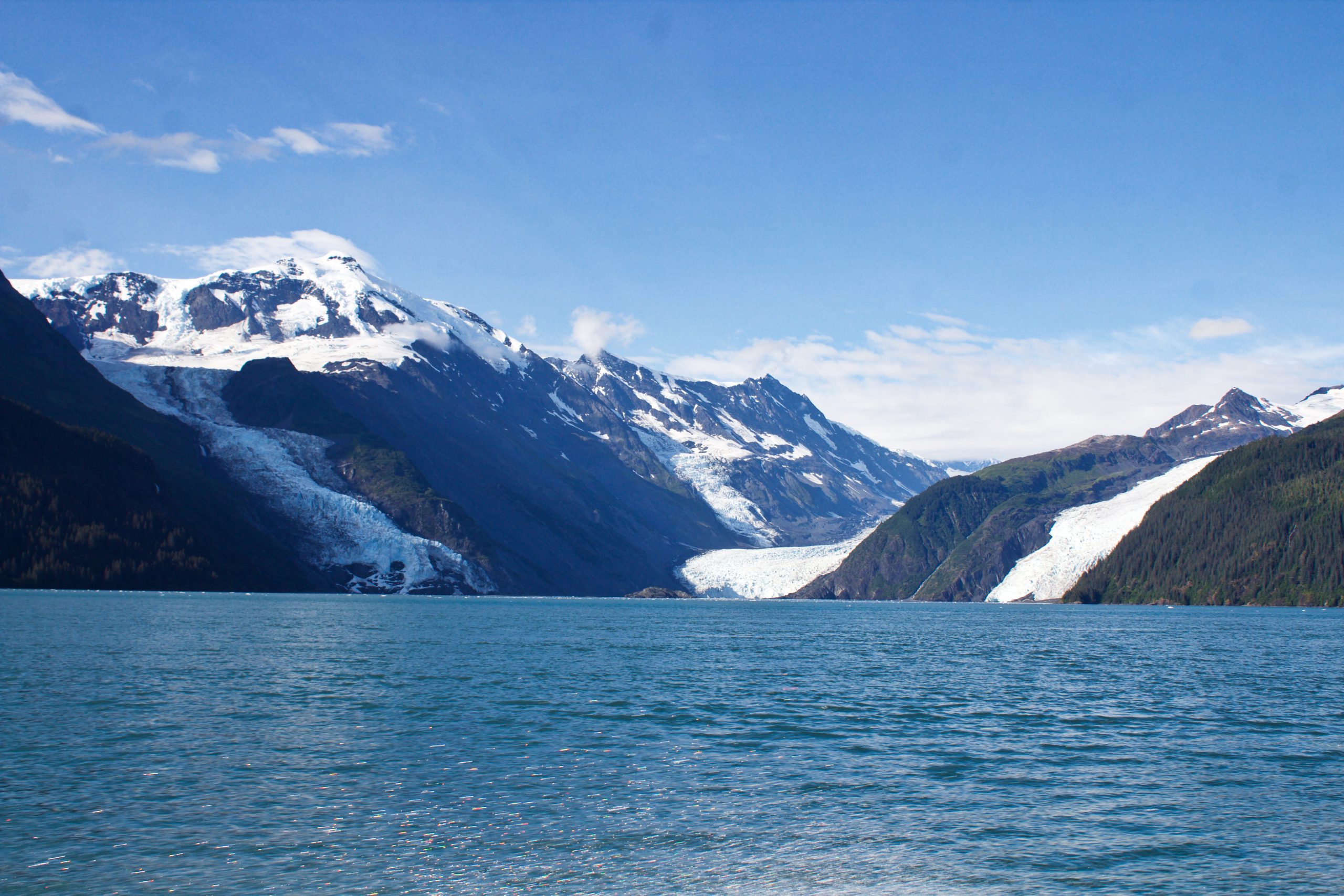
In May of 2020, local geologists identified a steep, unstable slope that has the potential to become a tsunami-generating landslide in Barry Arm, a glacial fjord 60 miles east of Anchorage, Alaska. With documented cases of tsunami-generating landslides in Alaska including Lituya Bay in 1958 and Taan Fjord in 2015, this new hazard immediately caught the attention of state and federal partners who quickly joined forces to quantify the risk to those living and boating in Alaska’s Prince William Sound, specifically the communities of Whittier, Valdez, Cordova, Tatitlek, and Chenega.

Continue reading “NOAA bathymetric data helps scientists more accurately model tsunami risk within Barry Arm”

NOAA navigation response teams complete hydrographic surveys following Hurricane Laura

Lt. John Kidd operates the NRT-Stennis vessel in Devil's Elbow.

Hurricane Laura, the first major hurricane of the 2020 Atlantic Hurricane Season, made landfall over Louisiana in the early morning hours of Thursday, August 27. As a Category 4 storm and with maximum sustained winds reaching 150 miles per hour, it caused significant damage along the Gulf coasts of Louisiana and southeastern Texas. For NOAA’s Office of Coast Survey –  whose job it is to identify dangers to navigation and help speed the reopening of ports and waterways following severe storms – this marked the first hydrographic survey response effort of the hurricane season.

Continue reading “NOAA navigation response teams complete hydrographic surveys following Hurricane Laura”

Nautical charts reflect alternate route along Gulf Intracoastal Waterway

Portion of Chandeleur Sound Gulf Intracoastal Waterway alternate route.

In anticipation of the temporary closure of the Gulf Intracoastal Waterway (GIWW)’s Inner Harbor Canal Lock, the Office of Coast Survey released three updated NOAA electronic navigational charts (NOAA ENC®) reflecting the Chandeleur Sound Alternate Route and the addition of 97 Aids to Navigation (ATON). The updated charts include US5LA24M, US4LA34M, and US4MS12M and can be viewed in NOAA’s ENC Viewer or downloaded from NOAA’s Chart Locator.

Continue reading “Nautical charts reflect alternate route along Gulf Intracoastal Waterway”

NOAA awards cooperative agreement to UNH/NOAA Joint Hydrographic Center

Students from the Center recovering a seafloor grab sampler.

NOAA’s Office of Coast Survey awarded a 5-year cooperative agreement to the University of New Hampshire for the continuation of the Joint Hydrographic Center. The Joint Hydrographic Center is a NOAA/University research and education partnership aimed at maintaining a world-leading center of excellence in hydrography and ocean mapping. The new award, which will begin in January 2021, will build on the work of the Center since its founding in 1999. 

Continue reading “NOAA awards cooperative agreement to UNH/NOAA Joint Hydrographic Center”

NOAA Coast Survey’s new strategy supports charting mandates and broader seafloor mapping

This week, NOAA’s Office of Coast Survey released the Mapping U.S. Marine and Great Lakes Waters: Office of Coast Survey Contributions to a National Ocean Mapping Strategy. This report is part of NOAA’s ongoing commitment to meet core surveying and nautical charting mandates while supporting broader needs to fill gaps in seafloor mapping and environmental sciences.

Continue reading “NOAA Coast Survey’s new strategy supports charting mandates and broader seafloor mapping”

Coast Survey Spotlight: Meet Fernando Ortiz

As a physical scientist, Fernando conducts a variety of tasks. One of his primary tasks is to review sonar and multibeam data as a quality control check. These reviews ensure that our data is accurate enough to ensure safe navigation.

Ever wonder what it’s like to be a member of the NOAA Coast Survey team? We use the Coast Survey spotlight blog series as a way to periodically share the experiences of Coast Survey employees as they discuss their work, background, and advice.


Fernando Ortiz, Physical Scientist

“It’s rewarding to be able to utilize new scientific technologies and processes to collect this necessary data.”

Continue reading “Coast Survey Spotlight: Meet Fernando Ortiz”

Nautical Chart Manual guides cartographers for 100 years

By John Macek

This July marks the 100th anniversary of the Office of Coast Survey’s Nautical Chart Manual. First published on July 10, 1920, as Special Publication No. 66, under the title “RULES AND PRACTICE RELATING TO CONSTRUCTION OF NAUTICAL CHARTS”, the 34- page pamphlet codified the essential guidelines to be used by cartographers of the U.S. Coast and Geodetic Survey.

Continue reading “Nautical Chart Manual guides cartographers for 100 years”

United States Coast Pilot® covering the Pacific now in two volumes

Coast Pilot 10 cover

What is currently known as United States Coast Pilot® 7 was first published in 1903. The official published name was United States Coast Pilot—Pacific Coast California, Oregon and Washington. Content and information was inclusive of those three states. After Hawaii became a state in 1959, information on the Hawaiian Islands—including the long string of islands and atolls out to Midway Island—was incorporated into the newly titled United States Coast Pilot 7—Pacific Coast California, Oregon, Washington and Hawaii. In 1988, information originally maintained by the National Geospatial-Intelligence Agency under Publication 126 on the remote Pacific Islands (American Samoa, Guam and the Marianas) was added as a new chapter.

Continue reading “United States Coast Pilot® covering the Pacific now in two volumes”

Coast Survey Spotlight: Meet Glen Rice

Glen Rice embarking on the "NOAA Ship Nancy Foster" to conduct acceptance testing to confirm proper operation of a newly installed multibeam system.

Ever wonder what it’s like to be a member of the NOAA Coast Survey team? We use the Coast Survey spotlight blog series as a way to periodically share the experiences of Coast Survey employees as they discuss their work, background, and advice.


“Coast Survey serves the public important information that has a real impact both to national commerce and to the individual.”

Continue reading “Coast Survey Spotlight: Meet Glen Rice”

High-definition charts advance precision marine navigation

Vessel entering the port of Long Beach, California.

By Craig Winn, HD charting portfolio manager

For large vessels entering port where there is next to zero margin for error, pilots and shipmasters are looking for the highest resolution data available to help them navigate these tight spaces safely and efficiently. NOAA’s Office of Coast Survey recently constructed and released 16 high-definition (HD), band 6 (or berthing scale) electronic navigational charts for Los Angeles/Long Beach Harbor, providing mariners with the best charts available to do their job.

Continue reading “High-definition charts advance precision marine navigation”