
Lt. Thomas R. Gedney, a U.S. Navy officer commanding the U.S. Coast Survey Brig Washington on August 20, 1839, was surveying the area between New York’s Montauk Point and Gardiner’s Island. He “discovered a strange and suspicious looking vessel off Culloden Point, near said Montauk Point,” according to his statement to Connecticut District Court Judge Andrew T. Judson. Gedney and his officers took possession of the vessel. The ship captured by the Washington proved to be the Spanish schooner called L’Amistad – the ship carrying Africans who revolted against their captors and tried to sail back to Africa… Thus began a little known piece of U.S. Coast Survey history. (It is so little known, in fact, that the 1997 movie Amistad did not mention Coast Survey.)
Continue reading “Coast Survey’s little known role in the case of the Amistad”
NOAA Ship Rainier surveying the waters off Washington
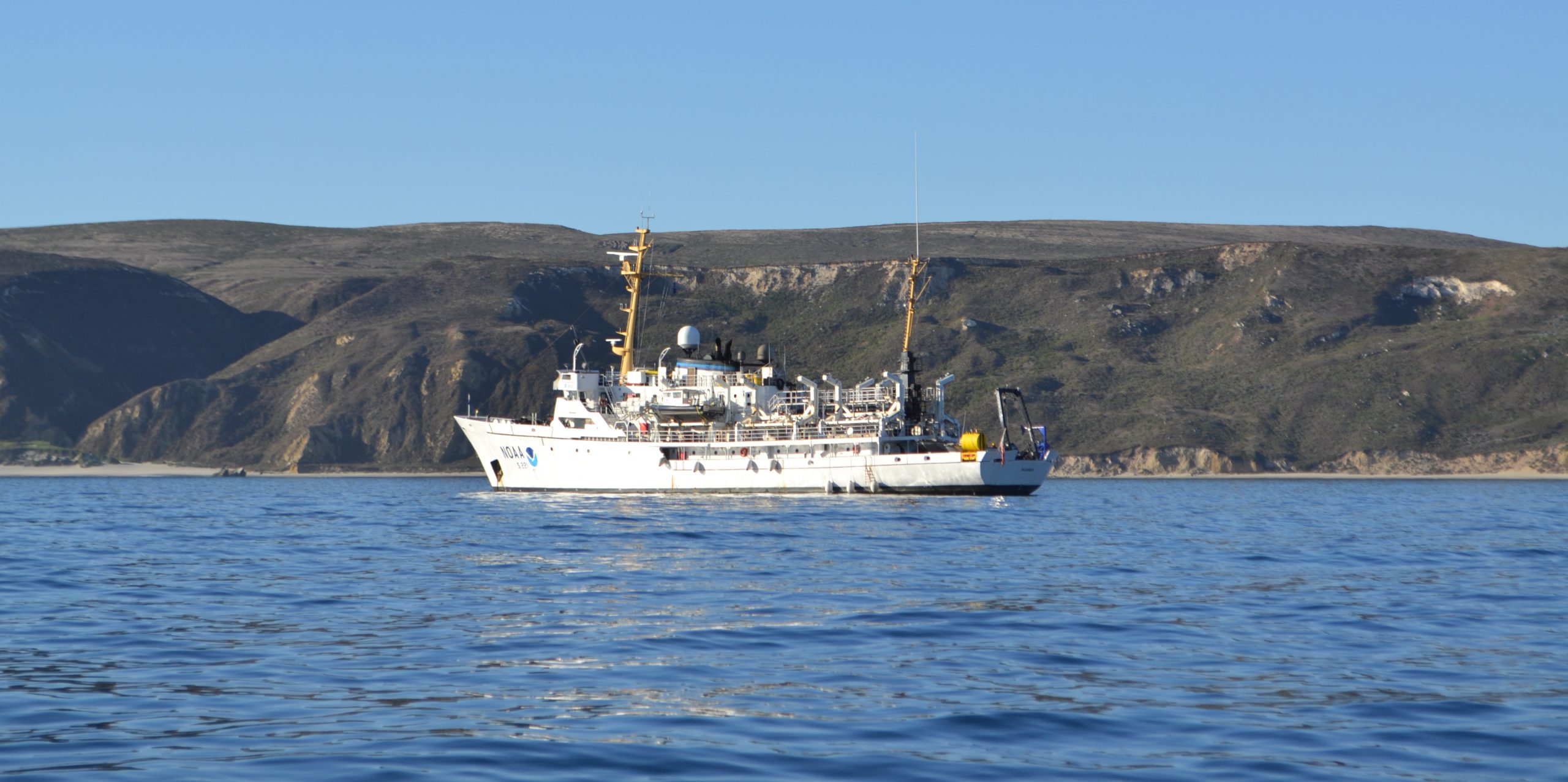
A NOAA ship plying the waters off the coast often inspires public curiosity. This is especially true when boaters and others see the ship or her launches just go back and forth, back and forth, all day. It’s not a surprise, then, that NOAA Ship Rainier’s latest project is generating questions from the areas around Protection Island and Lopez Island, Washington.
Don’t worry, there is no problem! NOAA’s Office of Coast Survey is collecting bathymetric data to update nautical charts that are currently displaying depth measurements acquired from surveys conducted from 1940 to 1969. Survey vessels go back and forth, in a maneuver that is similar to mowing the lawn, as they use multibeam echo sounders to measure the depths and to “see” the ocean floor. If any of the vessels discover a danger to navigation – an uncharted wreck or other obstruction, for instance – Coast Survey will immediately inform the U.S. Coast Guard and the information will be relayed to ships and boaters through a Local Notice to Mariners.
Continue reading “NOAA Ship Rainier surveying the waters off Washington”
New private hydro vessel adds to nation’s capabilities
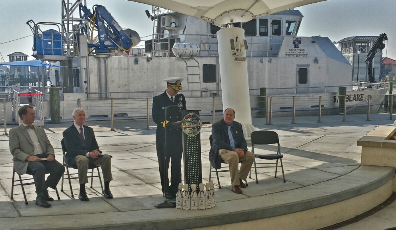
Under beautiful blue skies yesterday in Gulfport, Mississippi, David Evans and Associates, Inc. commissioned its new 82-foot hydrographic survey and scientific vessel Blake. Rear Admiral Gerd Glang, Coast Survey’s director, welcomed the addition to the nation’s hydrographic surveying assets. DEA is under contract to NOAA to provide critical hydrographic data for updating the nation’s nautical charts.
Continue reading “New private hydro vessel adds to nation’s capabilities”
Survey helps ensure safe “parking” for deep-draft vessel in SF
In preparation for the M/V TERN’s anticipated arrival this week in San Francisco Bay, the Coast Guard and Port of San Francisco asked Coast Survey for a bathymetric survey of the proposed anchorage site. TERN is a semi-submersible vessel with a 60-foot draft, and the proposed anchorage site has charted depths of 62 feet and 63 feet ‒ leaving no room for error, to say the least. The question was whether there are any spots shoaler than 62 feet.
This isn’t your everyday anchorage.
Continue reading “Survey helps ensure safe “parking” for deep-draft vessel in SF”
NOAA is open for business with navigation industry
At the first NOAA Navigation Industry Day, held October 10 in conjunction with the Annapolis Boat Show, over two dozen of the world’s top maritime app and navigation system developers met with NOAA experts to learn more about the vast amounts of NOAA data that is available for free access and use.

Continue reading “NOAA is open for business with navigation industry”
NOAA Ship Thomas Jefferson celebrates survey success with maritime community
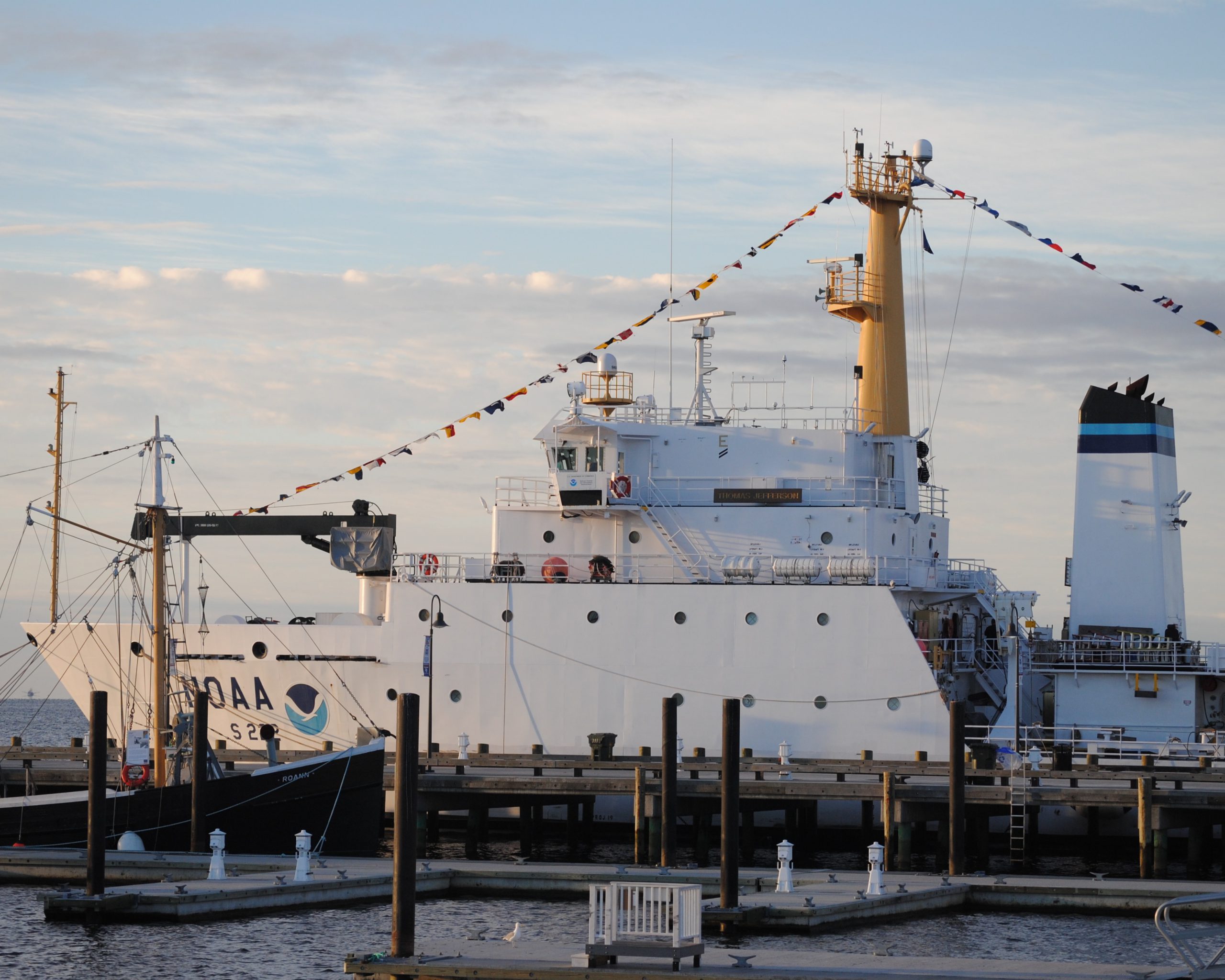
by Ensign Diane Perry, onboard NOAA Ship Thomas Jefferson
From 2005 through today, NOAA Ship Thomas Jefferson has been surveying Long Island Sound, one project area at a time. Some of the area was last surveyed between the late 1800s and 1939. For the 2014 field season, Thomas Jefferson was assigned her final Long Island Sound project, 89 square nautical miles of Eastern Long Island Sound, Fisher Island Sound, and Western Block Island Sound. When this project is complete, we will have resurveyed over 95% of Long Island Sound and all of Block Island Sound with modern survey technology that allows for a complete picture of the seafloor and highly accurate soundings.

Continue reading “NOAA Ship Thomas Jefferson celebrates survey success with maritime community”
A “soft” resilience strategy is part of successful hurricane response
We hear about the infrastructure investments that often follow major disasters like hurricanes ‒ the “hard” port resilience strategies necessary in the wake of catastrophic human, environmental, and economic loss. But the sturdiest, most flood-proof building is just one part of a larger system of assets in coastal resilience. We don’t hear much about the “soft” resilience strategies ‒ those that build and maintain ties among the people responsible for responding to a hurricane, for instance ‒ that are important to a successful response. Those strategies are part of the social capital between communities and government, and among government agencies.

Continue reading “A “soft” resilience strategy is part of successful hurricane response”
NOAA helps Port Fourchon determine safe anchorage areas
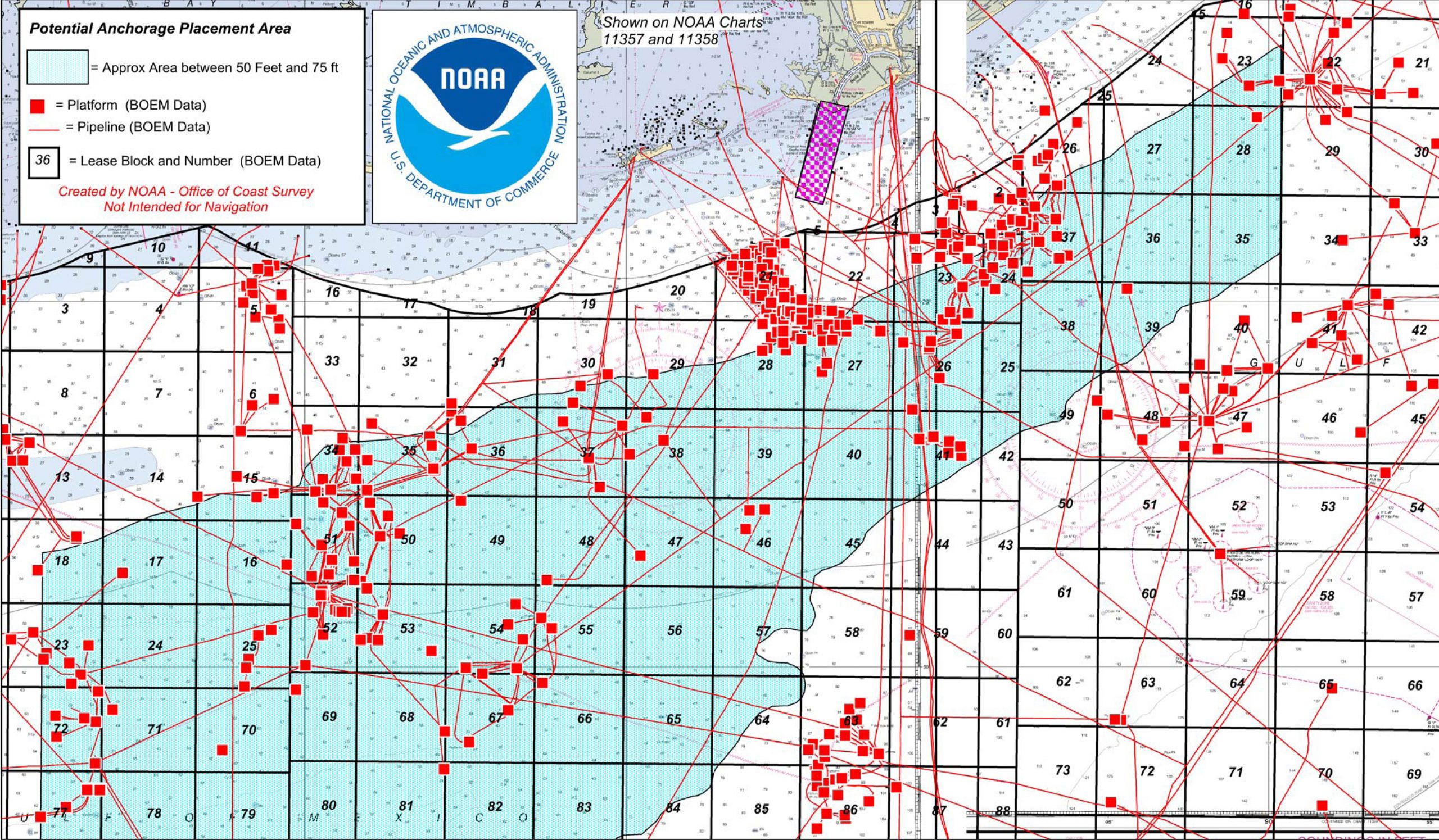
Port officials around the country know they can rely on the expert advice of Coast Survey’s navigation managers, cartographic experts, and hydrographers as the ports plan the essential improvements necessary for a thriving maritime economy. One example of Coast Survey assistance is in Port Fourchon, Louisiana, where port officials have determined that the volume and density of vessels have reached a level that requires one or more offshore anchorage areas. Sending vessels to a designated anchorage reduces the population in port and provides a safe area for vessels to power down their engines (rather than hold in place offshore in dynamic positioning mode), which would improve both safety and efficiency in the area known as the “Gulf’s Energy Connection.”
Continue reading “NOAA helps Port Fourchon determine safe anchorage areas”
Lt. Smith shows us the beauty of Gambell Alaska

This summer, the Bering Sea Alliance hosted a private-public summit in Gambell, Alaska, to discuss Arctic resource development and infrastructure. (See page 10 in this edition of the Nome Nugget for a good summary of the meeting.) Lt. Tim Smith, NOAA Coast Survey’s regional manager for Alaska, updated the participants on the status of Arctic nautical charts and described NOAA’s Arctic Nautical Charting Plan. He also outlined the preliminary 2015 survey plans to acquire hydrographic data around Point Hope, Point Barrow, Port Clarence, and Kotzebue Sound, as NOAA strives to ensure the navigational safety of the increasing ship traffic through Arctic waters.
Continue reading “Lt. Smith shows us the beauty of Gambell Alaska”
NOAA awards contract to build new navigation response boats
NOAA today announced that Lake Assault Boats of Superior, Wisconsin, will build two small vessels for the Office of Coast Survey’s navigation response program, part of a plan to eventually replace all six of the program’s small survey boats. The combined cost of both 28-foot vessels is $538,200.
“All of the navigation response team survey boats are nearing or have exceeded their designed service life,” said Russ Proctor, division chief of Coast Survey’s Navigation Services Division. “A phased program to replace the navigation response team boats over the next three to five years will help NOAA maintain the program’s crucial capacity for inshore surveys and rapid response in emergencies.”
Continue reading “NOAA awards contract to build new navigation response boats”