 An
official website of the United States government.
Here's how you know we're official.
An
official website of the United States government.
Here's how you know we're official.
An
official website of the United States government.
Here's how you know we're official.
An
official website of the United States government.
Here's how you know we're official.
Office of Coast Survey
National Oceanic and Atmospheric Administration
U.S. Department of Commerce
Determining the Hydrographic Survey Needs of the Nation
NOAA provides nautical charts and other products for the safe navigation of all mariners and maritime commerce for 3.4 million square nautical miles of U.S. waters. Updates to these nautical charts are, in part, accomplished by conducting hydrographic surveys that measure and describe the physical features of the seafloor in a body of water. However, due to the vast extent of U.S. waters and limited time and hydrographic surveying resources, U.S. waters must be prioritized for hydrographic survey to maximize efficiency.
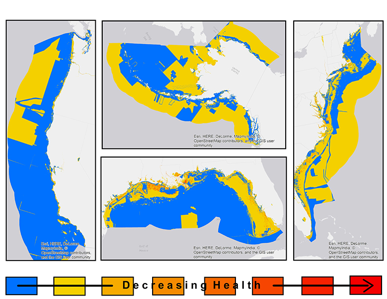 Hydrographic Health Model
In the past, areas were prioritized for hydrographic survey using NOAA's hydrographic survey priorities (NHSP) model, which was last updated in 2012. Currently, Coast Survey is in the process of implementing an updated survey prioritization model - the hydrographic health model. NOAA has new data inputs and a more precise knowledge of weather and ocean processes than before. Moving forward, NOAA will define hydrographic survey plans based on this model.
The hydrographic health model is a risk-based model that takes into account navigational risks, including both the likelihood of a risk (e.g. traffic density, known hazards to navigation, reported ship groundings, etc.) and the consequence of a risk (proximity to search and rescue stations, proximity to reefs or marine sanctuaries, etc.). The model also considers the necessary quality of data to support modern traffic relative to what is currently available, given the seafloor changes over time. Seafloor changeability takes into account the frequency of storms, current speed, and accumulation of marine debris, where the quality of data in highly changeable areas decreases faster than the quality of data in less changeable areas. Using historic knowledge of seafloor changeability, the model can also approximate the future quality of survey data and assess how often an area needs resurveying.
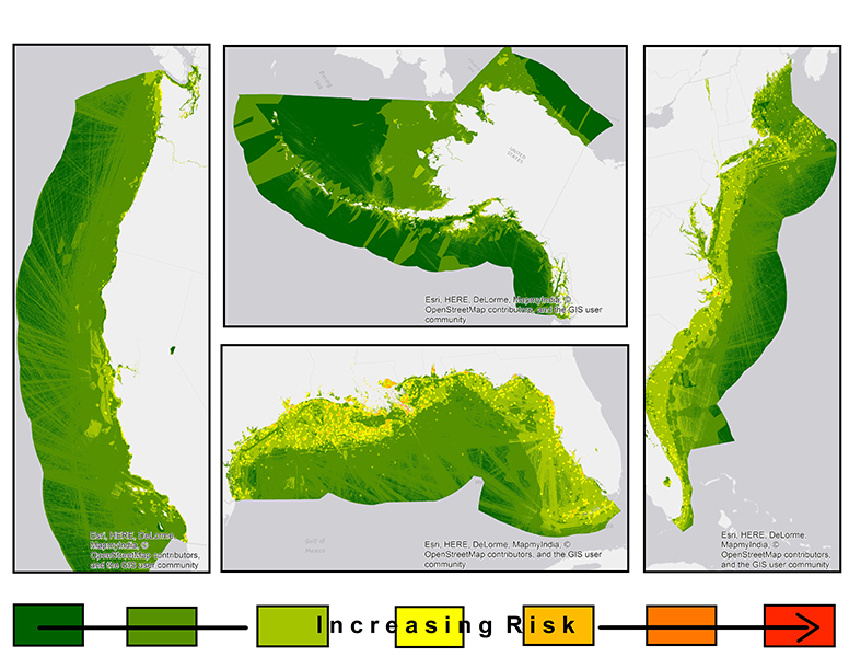 Hydrographic Risk Model
NOAA's new hydrographic health model will ultimately be more transparent than the previous model, and easier to communicate to our stakeholders and the public. With the emergence of new ports, vessels with deeper drafts, and increases in the maritime user community, NOAA works to ensure the continued safety of maritime transportation.
During this transition period to the new hydrographic health model, please direct all questions to ASSIST.