New hydrographic surveying matching fund announced

Update (2/19/21) – Notes and slides from the January 28, 2021, webinar on the NOAA Coast Survey Matching Fund Opportunity are now available.

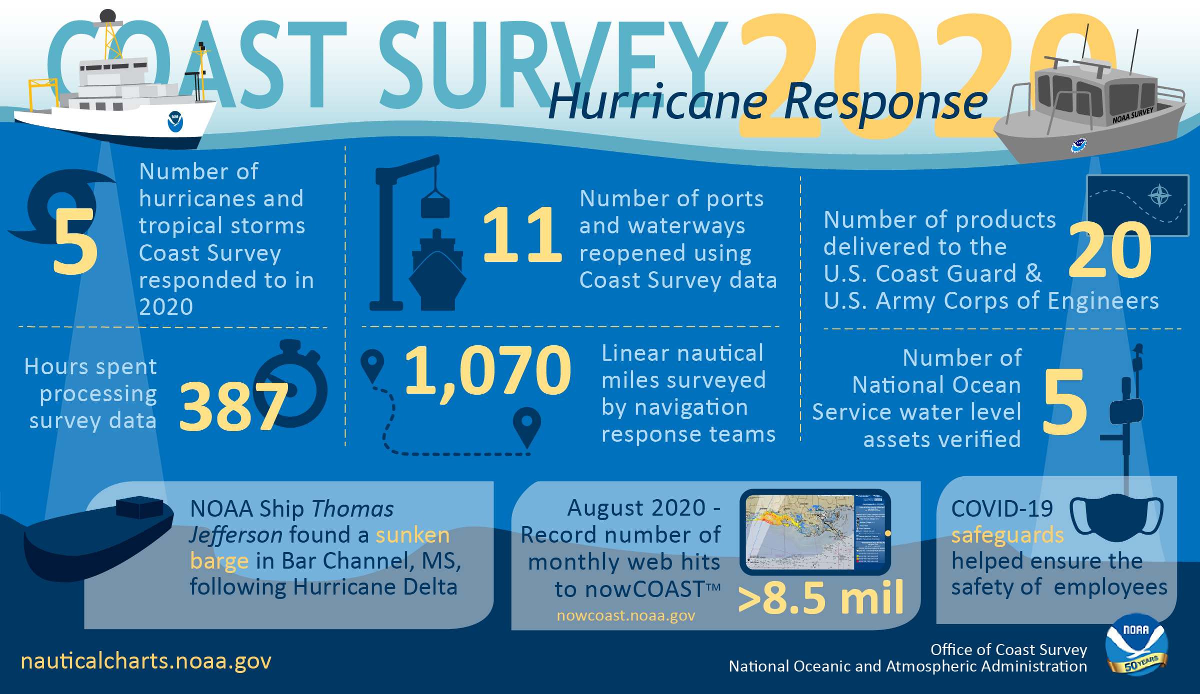
NOAA’s Office of Coast Survey recently announced a new pilot program for a Hydrographic Surveying Matching Fund opportunity through a Federal Register Notice. The purpose of this notice is to encourage non-federal entities to partner with NOAA on jointly-funded hydrographic surveying, mapping, and related activities of mutual interest. The pilot program relates directly to Coast Survey’s Ocean Mapping Plan and a goal to expand U.S. EEZ mapping by also expanding use of Coast Survey’s hydrographic services contract vehicle.

Continue reading “New hydrographic surveying matching fund announced”

By the Numbers: Coast Survey’s 2020 Atlantic Hurricane Season

NOAA Office of Coast Survey 2020 hurricane season infographic

As the 2020 Atlantic hurricane season came to a close on November 30, NOAA’s Office of Coast Survey tallied a few numbers to see what the combined response effort of the navigation response teams, NOAA Ship Thomas Jefferson, and hydrographic survey contractor David Evans & Associates, Inc., looked like.  

Continue reading “By the Numbers: Coast Survey’s 2020 Atlantic Hurricane Season”

NOAA Ship Thomas Jefferson returns to survey approaches to Chesapeake Bay during the 2020 field season

NOAA Ship Thomas Jefferson

By Hydrographic Assistant Survey Technician Sophia Tigges

For the first portion of the 2020 field season, NOAA Ship Thomas Jefferson surveyed approaches to Chesapeake Bay. Thomas Jefferson’s 2020 field season consisted of two 45-day “bubble” periods. A “bubble period” is the time a ship closes to personnel transfer while they shelter in place for seven days and undergo COVID-19 testing per NOAA’s Office of Marine and Aviation Operation’s COVID-19 protocol to mitigate exposure. The ship spent the entire first bubble working off the coast of North Carolina and Virginia for this project. These surveys served as a continuation of the ship’s work in the area in the 2019 season.  (To learn more about Thomas Jefferson’s work in this area last year, read the 2019 post titled, “NOAA Ship Thomas Jefferson tests innovative DriX unmanned surface vehicle.”

Continue reading “NOAA Ship Thomas Jefferson returns to survey approaches to Chesapeake Bay during the 2020 field season”

Make your voice heard: Provide input on ocean mapping, exploration, and characterization efforts in the U.S. EEZ

Underwater scene

The National Ocean Mapping, Exploration, and Characterization Council (NOMEC Council), a group of federal agencies established to carry out the National Strategy for Mapping, Exploring, and Characterizing the United States Exclusive Economic Zone, requests your input on developing an Implementation Plan and setting strategic priorities for the effort to map the entire U.S. Exclusive Economic Zone (EEZ) by 2040 and explore and characterize strategic areas.

Continue reading “Make your voice heard: Provide input on ocean mapping, exploration, and characterization efforts in the U.S. EEZ”

NOAA concludes hydrographic survey response following Hurricane Delta

NOAA Ship Thomas Jefferson Launch 2904 surveying the Bar Channel, Calcasieu, Louisiana Approach.

This week NOAA’s Office of Coast Survey concluded its hydrographic survey response following Hurricane Delta. At the immediate request of the U.S. Army Corps of Engineers (USACE), NOAA’s navigation response teams (NRTs) and NOAA Ship Thomas Jefferson surveyed areas within the Gulf Intracoastal Waterway (GIWW), Calcasieu Ship Channel, and the entrance to the channel. With lessons learned from the response to Hurricane Laura — the first major hurricane of the 2020 season and the first hurricane response during a pandemic — the teams and Thomas Jefferson successfully collected, processed, and delivered data to the USACE, identifying significant hazards to navigation and helping to ensure the timely reopening of waterways.

Continue reading “NOAA concludes hydrographic survey response following Hurricane Delta”

Autonomous vessel operations in the Arctic: Lessons learned from the Summer 2020 Mapping Mission

On May 28, 2020, four uncrewed vessels departed Alameda, California, to begin their transit across the Pacific Ocean, through Unimak Pass, across the Bering Sea, and into the Arctic. These small, uncrewed vessels, powered only by wind and sun, arrived at Point Hope, Alaska, in early August to start an ambitious project acquiring new depth data along the 20 and 50 meter depth contours from Point Hope to the Canadian border. This was the start of a challenging Arctic project that would contend with weather, sea ice, and equipment failures, all while avoiding potential conflicts with indigenous subsistence hunting. 

Continue reading “Autonomous vessel operations in the Arctic: Lessons learned from the Summer 2020 Mapping Mission”

NOAA bathymetric data helps scientists more accurately model tsunami risk within Barry Arm

Barry Glacier, Alaska.

In May of 2020, local geologists identified a steep, unstable slope that has the potential to become a tsunami-generating landslide in Barry Arm, a glacial fjord 60 miles east of Anchorage, Alaska. With documented cases of tsunami-generating landslides in Alaska including Lituya Bay in 1958 and Taan Fjord in 2015, this new hazard immediately caught the attention of state and federal partners who quickly joined forces to quantify the risk to those living and boating in Alaska’s Prince William Sound, specifically the communities of Whittier, Valdez, Cordova, Tatitlek, and Chenega.

Continue reading “NOAA bathymetric data helps scientists more accurately model tsunami risk within Barry Arm”

NOAA navigation response teams complete hydrographic surveys following Hurricane Laura

Lt. John Kidd operates the NRT-Stennis vessel in Devil's Elbow.

Hurricane Laura, the first major hurricane of the 2020 Atlantic Hurricane Season, made landfall over Louisiana in the early morning hours of Thursday, August 27. As a Category 4 storm and with maximum sustained winds reaching 150 miles per hour, it caused significant damage along the Gulf coasts of Louisiana and southeastern Texas. For NOAA’s Office of Coast Survey –  whose job it is to identify dangers to navigation and help speed the reopening of ports and waterways following severe storms – this marked the first hydrographic survey response effort of the hurricane season.

Continue reading “NOAA navigation response teams complete hydrographic surveys following Hurricane Laura”

NOAA awards cooperative agreement to UNH/NOAA Joint Hydrographic Center

Students from the Center recovering a seafloor grab sampler.

NOAA’s Office of Coast Survey awarded a 5-year cooperative agreement to the University of New Hampshire for the continuation of the Joint Hydrographic Center. The Joint Hydrographic Center is a NOAA/University research and education partnership aimed at maintaining a world-leading center of excellence in hydrography and ocean mapping. The new award, which will begin in January 2021, will build on the work of the Center since its founding in 1999. 

Continue reading “NOAA awards cooperative agreement to UNH/NOAA Joint Hydrographic Center”