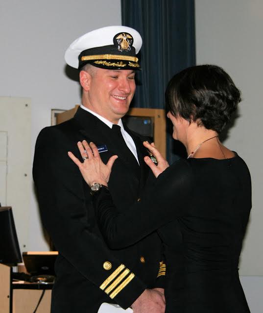
The crew of NOAA Ship Rainier (S-221) hosted a change of command on January 12 while moored in its homeport of Newport, Oregon.
Cmdr. John Lomnicky accepted command of Rainer, replacing Capt. Edward Van Den Ameele in a ceremony with crew and guests in attendance, including Rear Adm. Shepard Smith, director of NOAA’s Office of Coast Survey; Capt. Todd Bridgeman, director of Marine Operations, OMAO; Mayor Sandra Roumagoux, Newport, Oregon; and Cmdr. Brian Parker, commanding officer of Pacific Marine Operations Center. Continue reading “Change of command for NOAA Ship Rainier”
NOAA homeports navigation response team at Stennis Space Center, Mississippi
NOAA’s Office of Coast Survey announced that they will homeport one of their six navigation response teams at the John C. Stennis Space Center, Mississippi. The team will be co-located with NOAA’s National Data Buoy Center (NDBC) and adjacent to other federal and state partners involved in seafloor mapping and unmanned hydrographic survey systems.
“Coast Survey strategically places navigation teams around the country, and having a team permanently based at Stennis will speed our response to navigational emergencies in the Gulf,” said Rear Admiral Shepard Smith, Coast Survey director. “We are also looking forward to potential collaboration on emerging hydrographic technologies with our partners there.”
Continue reading “NOAA homeports navigation response team at Stennis Space Center, Mississippi”
NOAA survey ships adopt laser scanners to improve safety at sea
How tall is that rock, really? Is that islet charted correctly? Mariners will have greater confidence in the location and height of charted features as NOAA’s hydrographic ships increase their use of newly adopted laser technology to measure and locate topographical features like rocks, islets, and small islands.
Continue reading “NOAA survey ships adopt laser scanners to improve safety at sea”
Season’s Greetings
U.S. and Cuba work on navigation safety improvements
First up, improving charts and geodesy for Straits of Florida
Coast Survey welcomed Cuban colleagues to NOAA offices this week, as representatives of Cuba’s National Office of Hydrography and Geodesy (ONHG) traveled to Maryland for the first time since last December. In March, NOAA and ONHG signed a Memorandum of Understanding in Havana.
Continue reading “U.S. and Cuba work on navigation safety improvements”
Fast chart update of navigation danger protects Georgia boaters
Thanks to a combination of determination and technical advancements, Coast Survey was able to locate, report, and chart a danger to navigation within two weeks – a major improvement over the three-to-ten-year chart update protocol of only a few years ago.
On Monday, November 14, a Coast Survey navigation response team hit the waters of St Simons Sound, off the coast of Georgia, when the U.S. Coast Guard asked us to find a sunken fishing vessel. By the next morning, the team of James Kirkpatrick and Kyle Ward (who augmented on the project, from his normal duty as navigation manager in Charleston), reported to the Coast Guard, noting that the wreck is very shoal. They also observed recreational vessels transiting the area every 10 to 15 minutes. Coast Survey quickly issued an official Danger to Navigation Report.
Continue reading “Fast chart update of navigation danger protects Georgia boaters”
NOAA releases new nautical chart for the Port of Palm Beach, Florida
NOAA has issued a new nautical chart for the Port of Palm Beach, Florida, an important distribution center for commodities being shipped all over the world, and especially the Caribbean Basin.
The Port of Palm Beach operations include containerized, dry bulk, liquid bulk, break-bulk, and heavy-lift cargoes. It is the only port in South Florida with an on-dock rail where the Florida East Coast Railway provides twice-daily service to the port’s rail interchange.
Continue reading “NOAA releases new nautical chart for the Port of Palm Beach, Florida”
What does a zip file have to do with historic slave ship AMISTAD?
History is never completely written. There are always new discoveries, new understanding.
NOAA historian John Cloud recently sent Coast Survey an intriguing report:
Yesterday I was looking for some historic Chesapeake Bay T sheets [topography drafts]… Anyway, down in the bottom of a folder, there was a zipped file, dated 2009, never unzipped. I thought: well, since I have noticed this now, why don’t I unzip it? It turned out to be two overly rescaled jpgs, but using my Keith Bridge tricks [a technique developed by a former Coast Survey historical chart expert] I found the two full-scale originals. It was one chart, with a small part cut off to make two separate files: the original 1838 hydrography for New Haven Harbour!
Continue reading “What does a zip file have to do with historic slave ship AMISTAD?”
NOAA helps four ports recover from Hurricane Matthew
Matthew became a hurricane on Thursday, September 29, and it was soon clear that NOAA’s navigation services would be called into action. Coast Survey knew they would be needed for the maritime transportation system’s rapid recovery operations, to search for underwater debris and shoaling. That Saturday, while Hurricane Matthew was still three days away from hitting Haiti, Coast Survey was already ramping up preparations for assisting with reopening U.S. shipping lanes and ports after Matthew’s destruction. By Monday, as NOAA’s National Hurricane Center zeroed in on a major hit to the southeast coast, Coast Survey’s navigation service personnel began moving personnel and survey vessels for rapid deployment. Calling in survey professionals from as far away as Seattle, teams were mobilized to locations outside of the hurricane’s impact zones, so they would be ready to move in and hit the water as soon as weather and ocean conditions allowed.
Continue reading “NOAA helps four ports recover from Hurricane Matthew”
Coast Survey positioned to assist with port recovery
As Hurricane Matthew bore down on Florida, Georgia, and South Carolina, Coast Survey pre-positioned hydrographic survey vessels for immediate deployment, to help speed the reopening of commercial shipping at ports hit by high winds and storm surge.
Currently, our Central Coast Gulf navigation manager, Tim Osborn, embedded in Port Canaveral, Florida, and our Southwest navigation manager, Kyle Ward, are coordinating marine transportation system recovery priorities with the U.S. Coast Guard and port stakeholders in Florida, Georgia, South Carolina, and North Carolina.
Continue reading “Coast Survey positioned to assist with port recovery”