 An
official website of the United States government.
Here's how you know we're official.
An
official website of the United States government.
Here's how you know we're official.
An
official website of the United States government.
Here's how you know we're official.
An
official website of the United States government.
Here's how you know we're official.
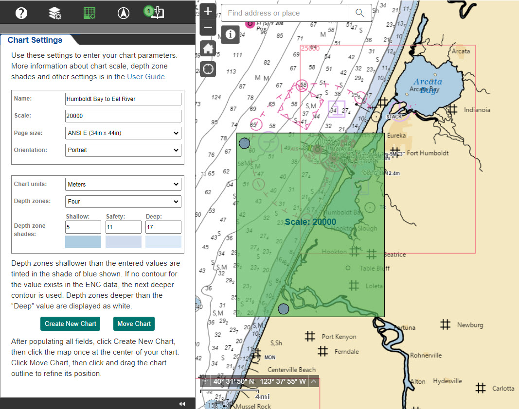
What is the NOAA Custom Chart application?
The NOAA Custom Chart (NCC) application enables users to create their own customized nautical charts directly from the latest official NOAA electronic navigational chart (NOAA ENC®) data.
Depths can be displayed in meters, feet, or fathoms and there are a few other display options, such as changing the depth at which a shallow water blue tint is applied and the depiction of a safety contour based on a vessel's draft.
NCC outputs geospatially referenced Portable Document Format (PDF) files using the paper size, scale, and location selected by the user. Users can save their custom chart parameters in a personal chart catalog that can be reloaded into NCC at a later date to refresh the chart with NOAA ENC data, updated every weekday. Chart catalogs are GeoJSON files composed of text in a format used for encoding a variety of geographic data structures using JavaScript Object Notation. These small text files, about one kilobyte for each chart saved in a catalog, can be emailed to easily share chart designs with others.
NOAA Custom Charts do not have identifying chart numbers and U.S. Coast Guard Local Notices to Mariners are not issued for these charts. The U.S. Coast Guard continues to provide information about changes to aids to navigation and newly identified dangers to navigation in the Local Notices to Mariners. However, references to NOAA traditional chart numbers have been replaced with harmonized waterway names to provide the general location of changed features in the Local Notice to Mariners in addition to the precise longitude and latitude of each change.
Chart catalog GeoJSON files may be imported into the NOAA Navigation Updates application to determine if any of the NOAA ENC data used to make a custom chart has been updated since the chart was last exported. The NOAA Navigation Updates application identifies critical corrections published in the Local Notices to Mariners that have been applied to NOAA ENC data, as well as routine non-critical corrections that are regularly released in NOAA ENC revisions. The application displays corrections in a map and provides textual information about each correction. Charts in the catalog are tagged as either having updates "available" or "none." Charts with updates available can easily be re-exported in the NCC application with the latest NOAA ENC data applied.
Custom charts created for 8.5-by-l 1-inch letter or 8.5-by-14-inch legal size paper may be printed on an ordinary home printer, but these small paper sizes are not generally practical for navigation. Commercial printers are able to print large format custom charts and NOAA maintains a list of vendors that have experience in printing and shipping nautical charts. Some Office Stores / Centers may also provide services which allow users to print PDF files at various sizes using a variety of paper stock.
The data portrayed on custom charts is referenced to the World Geodetic System 1984 (WGS84) and charts are created in the Mercator projection. The best output is produced when the scale of the custom chart matches the scale of the available NOAA ENC data. Custom charts are composed in a standard rectangular format featuring a single chart panel—there are no insets. The data on the chart is portrayed in a manner similar to traditional paper nautical charts, showing soundings, buoys, beacons and other aids to navigation, compass roses and the like, although some chart symbols may differ slightly. Information pertaining to the chart, such as a graphic and a representative fraction scale, and other marginalia appears below or to the side of the chart panel.
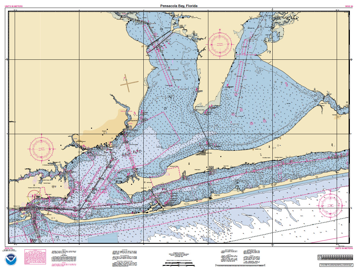 NOAA Custom Chart of Pensacola Bay, Florida
Separate 8.5-by-11-inch PDF pages contain notes and a zone of confidence or ZOC diagram, similar to the survey source diagrams seen on traditional nautical charts.
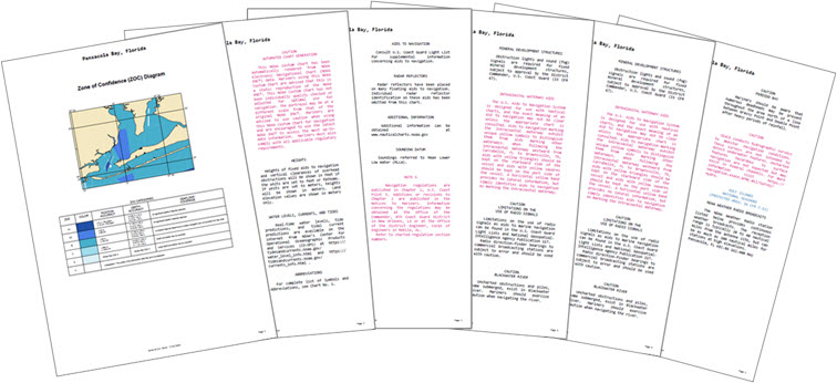 Zone of confidence (ZOC) diagram and notes pages for a Pensacola Bay
chart
Zone of confidence (ZOC) diagram and notes pages for a Pensacola Bay
chart
Frequently Asked Questions
You can save custom chart parameters—scale, paper size, extent, etc.—in a chart catalog GeoJSON file. The file can then be input into the online NOAA Navigation Updates application to determine if any of the NOAA ENC data used by NCC to create the chart has been updated since the chart was last exported.
The NOAA Navigation Updates website identifies critical corrections published in the Local Notices to Mariners that have been applied to the NOAA ENC data, as well as routine non-critical corrections that are regularly released in NOAA ENC revisions. The application displays corrections in a map and provides textual information about each correction. Charts in the catalog are tagged as either having updates "available" or "none." Charts with updates available can easily be re-exported in the NCC application with the latest ENC data applied.
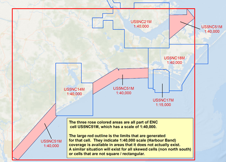
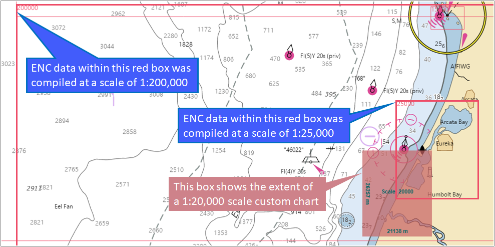
Unlike popular online maps or car navigation systems, which often provide a seemingly seamless map display as users zoom in, nautical charts only have large-scale data in particular areas, such as ports. You can only build a custom chart with the ENC data that is available and with the level of detail provided at the scale in which the data was compiled.
For example, if you wanted to build a 1:20,000 scale chart for a trip from Buhne Point in Humboldt Bay, California to the Pedrazzini Boat Ramp on the Eel River, you might set a chart extent, as shown by the green box below, for a 34-by-44-inch (ANSI E) sheet. A red outline covering Arcata Bay to the northeast and Humboldt Bay to the southwest shows the extent of a 1:25,000 scale NOAA ENC cell. This is a slightly smaller scale than the 1:20,000 scale in which the custom chart will be created, but the difference is fairly small and the top right corner of the resulting chart should look fine.
However, the largest scale NOAA ENC coverage available for the bottom and left sides of the custom chart is 1:200,000. This provides much less detail than would normally be used for a 1:20,000 scale chart that NCC is being used to create. The extent of the smaller scale, much less detailed NOAA ENC data that is available to fill in the rest of the chart is shown by the larger red outline in the image below.
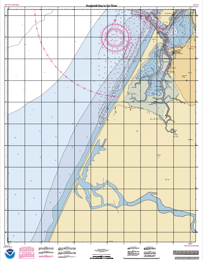
This difference is readily apparent in the resulting chart, shown below. The density of the soundings in the northeast quadrant of the chart is much greater, there are more depth contours shown, and the delineation of the sloughs in Humboldt Bay are shown in more detail than the banks of the Eel River shown in the southern portion of the chart.
The U.S. Coast Guard has asked that questions and comments regarding nautical chart
carriage requirements be directed to the U.S. Coast Guard Navigation Center at:
https://www.navcen.uscg.gov/contact/contact-us
There is a growing demand for ever more detailed nautical charts. To help meet this need, NOAA initiated a program to sunset its traditional paper nautical charts and the corresponding raster chart products and services. This has enabled NOAA to focus on improving the coverage and content of the digital chart format that is used throughout the world for navigation, the electronic navigational chart (ENC). ENC data is produced by over twenty other countries and used by mariners around the world.
Producing and distributing raster charts requires additional, separate computer software and data storage, as well as specialized cartographic training and processing beyond the resources needed to maintain ENCs alone. NOAA is carrying out an ambitious program to replace much of the existing NOAAA ENC coverage with more detailed (larger scale) data. When completed, the enhanced product suite will consist of over 7,300 ENCs in twelve standard scales. NOAA has only been able to create and maintain this enhanced suite of ENC products by redirecting resources previously used to update and distribute traditional paper and raster nautical charts.
Custom charts created for 8.5-by-11-inch letter or 8.5-by-14-inch legal size paper may be printed on an ordinary home printer, but these small paper sizes are not generally practical for navigation. Commercial printers are able to print large format custom charts and NOAA maintains a list of vendors that have experience in printing and shipping nautical charts.
Portable Document Format (PDF) is the only output provided by the NOAA Custom Chart application. The PDF is geospatially referenced, but NCC charts are not intended to be used in digital chart displays for navigation.
No, only specific paper sizes shown in the NCC chart settings control panel may be used. The placement of the chart grid, graphic scales, notes and other minformation must be pre-designed for each paper size and orientation used by NCC.
Yes, an updated User Guide was released with NCC version 3.0. This explains how the various application settings work and provides tips for creating the best customized charts. There is also a video that explains the basics of creating a custom chart and using the new personal chart catalog feature. Other resources are also available in the NCC Help & Feedback panel.
For further assistance or to suggest improvements for the NOAA Custom Chart application, questions or comments may be submitted through the Coast Survey's online ASSIST customer feedback tool.
If you have a question or suggestion concerning a particular custom chart that you are making, please let us know what area you are trying to build a chart for and attach the NCC geoJSON catalog file, the chart PDF or a screenshot of the area, if possible.
Canceled traditional nautical charts and any other previous versions of each chart are available in a JPEG (and sometimes PDF) formats in the NOAA Coast Survey Historical Map and Chart Collection. Canceled charts do not meet U.S. Coast Guard carriage requirements for regulated vessels and should not be used for navigation.