 An
official website of the United States government.
Here's how you know we're official.
An
official website of the United States government.
Here's how you know we're official.
An
official website of the United States government.
Here's how you know we're official.
An
official website of the United States government.
Here's how you know we're official.
What is the National Bathymetric Source Program?
Beneath the water surface in oceans, lakes, and rivers are areas of sand, rocks, mud, and bottom features known as bathymetry. The depth of water over the bathymetry is a limiting factor for the size of the ship that can safely navigate a region and is therefore a primary component of navigation products. The National Bathymetric Source (NBS) Program builds and maintains a seamless and high-resolution model-the National Bathymetry-compiled from the best available source data. The National Bathymetry is funneled into several distinct pipelines that differ in contributing sources, vertical datums, and formats to support user requirements. The program's workflow is designed for throughput to ensure that bathymetry is available to professional mariners and the public as soon as possible.
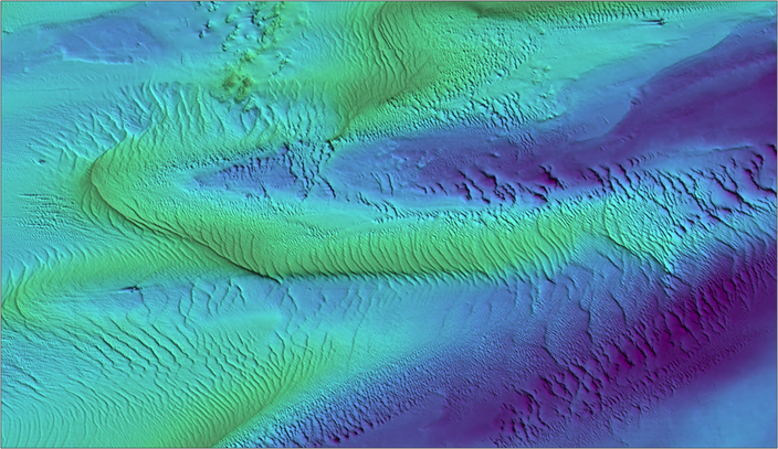 An image showing bathymetry in Long Island Sound.
NOAA's Office of Coast Survey is the nation's nautical charting authority in U.S. territorial waters. Nautical charts represent hydrographic data, providing detailed information on water depths, shorelines, tide predictions, obstructions to navigation such as rocks and shipwrecks, and navigational aids. They provide professional mariners and recreational boaters with the information they need to navigate safely over the seafloor. Historically, depth information on nautical charts has been drawn from many different, often sparse, bathymetric sources that can be difficult to access and update. The NBS program is part of a new Coast Survey workflow to modernize the nautical charting process and to provide a critical bathymetry resource to several customers, including the public. For example, the NBS program supports Precision Marine Navigation by delivering seamless, high-resolution bathymetric data to better equip professional mariners in making critical navigation decisions. BlueTopo™ is the public "not for navigation" compilation of bathymetry produced by Coast Survey.
What constitutes the best available bathymetry?
Bathymetry is measured through various survey methods that yield different levels of accuracy and precision. The National Bathymetry is the result of compiling the highest quality source data. The International Hydrographic Organization defines the quality of bathymetric data according to measurement uncertainty, feature detection capability, coverage, survey age, and changeability of the location. Generally, bathymetric source data are of the highest quality when there is low horizontal and vertical uncertainty and high resolution, and were acquired recently using the latest surveying specifications and techniques.
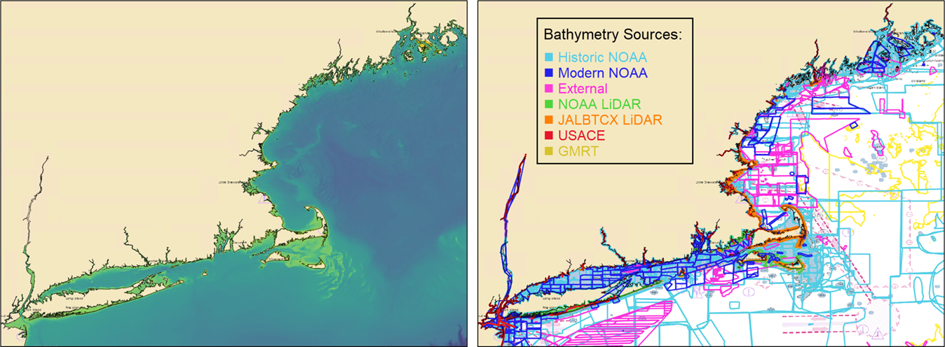
Primary sources of bathymetry in NBS program compilations include NOAA and U.S. Army Corps of Engineers hydrographic and topographic-bathymetric LiDAR data. Data submitted through Coast Survey's External Source Data process by federal, state, academic, and individual entities are also included. Contact esd.team@noaa.gov for more information about how to submit bathymetry data. Coverage gaps in water 200 meters or greater are filled in BlueTopo through Global Multi-Resolution Topography, a merged model of bathymetry made available through Lamont-Doherty Earth Observatory.
Recent, rapid technology advances have improved data quality significantly, but many areas around the U.S. haven't been surveyed in over 100 years, and in some cases haven't been surveyed at all. In addition to compiled bathymetry, the NBS program contains metadata with quality metrics from the source data to enable appropriate product use (e.g. horizontal and vertical uncertainty, feature detection size).
How is the National Bathymetric Source Program unique?
The NBS program is unique among other efforts to merge source bathymetry as the derived product represents the highest quality bathymetry available, carries forward source metadata, and directly supports safe navigation. Safe navigation products require acute attention placed on vertical and horizontal datum transformations and descriptions. The bathymetry merging process primarily evaluates hydrographic quality metrics of uncertainty, feature detection, and seafloor coverage while accounting for temporal and spatial variability. While navigation services are Coast Survey's primary mandate, the transparent metadata and merge algorithm that determines the best available bathymetry for navigation can also be used to support marine modeling and spatial planning.
How do I access the National Bathymetry?
The National Bathymetry is available primarily through our navigation pipelines; NOAA's electronic navigational chart and the International Hydrographic Organization's S-102 Bathymetric Surface Product Specification, which is a three-dimensional 'picture' of the bottom of the ocean or a high-definition gridded bathymetry product. BlueTopo is available to the public through NOAA's Open Data Dissemination Program and NOAA's nowCOAST™.
We look forward to hearing from you! Let us know how you use the National Bathymetry and how it has impacted your work. Please visit the FAQs page before contacting us with questions through ASSIST.