Surveying the Canadian Arctic aboard the icebreaker Henry Larsen

An image of the survey crew standing in front of a survey vessel aboard the deck of the icebreaker .

Annie Raymond, a member of one of NOAA’s navigation response teams, spent time in late summer aboard Canadian Coast Guard (CCG) icebreaker Henry Larsen in the Canadian Arctic with the Canadian Hydrographic Service (CHS). Her time aboard the ship was part of an exchange program designed as an opportunity for the Office of Coast Survey and CHS to gain exposure to each other’s field operations, particularly highlighting challenges for Arctic operations. Throughout the experience, she observed similarities and differences between Coast Survey and CHS data acquisitions and operations.

Continue reading “Surveying the Canadian Arctic aboard the icebreaker Henry Larsen”

NOAA contributes to Empowering Women in Hydrography through at-sea experience, part 6

An image of NOAA Ship Nancy Foster.

The Empowering Women in Hydrography project is a global effort led by the International Hydrographic Organization and Canada that seeks to initiate, organize and track a series of activities and initiatives which will enable more women to participate equitably in the field of hydrography and to assume leadership roles within the hydrographic community. NOAA is contributing to the project via an ‘at-sea experience’ on NOAA hydrographic ships for three women each year over the lifespan of the project. After a global call for nominations, three women were selected to join NOAA ships for the 2023 survey season. Lt. Lucía Cattana, from the Argentine Naval Hydrography Service, joined NOAA Ship Nancy Foster from 5 to 10 July 2023, while conducting surveys off the coast of South Carolina.

Continue reading “NOAA contributes to Empowering Women in Hydrography through at-sea experience, part 6”

NOAA contributes to Empowering Women in Hydrography through at-sea experience, part 5

A series of images showing Victoria Obura acquiring data on a survey launch, standing on the bridge of NOAA Ship Thomas Jefferson, and preparing to board the survey launch.

The Empowering Women in Hydrography project is a global effort led by the International Hydrographic Organization and Canada that seeks to initiate, organize and track a series of activities and initiatives which will enable more women to participate equitably in the field of hydrography and to assume leadership roles within the hydrographic community. NOAA is contributing to the project via an ‘at-sea experience’ on NOAA hydrographic ships for three women each year over the lifespan of the project. After a global call for nominations, three women were selected to join NOAA ships for the 2023 survey season. Victoria Obura, a Hydrographer from Survey of Kenya Hydrographic Office, joined NOAA Ship Thomas Jefferson from 12 June to 23 June 2023, while surveying offshore Galveston, Texas.

Continue reading “NOAA contributes to Empowering Women in Hydrography through at-sea experience, part 5”

NOAA contributes to Empowering Women in Hydrography through at-sea experience, part 4

NOAA Ship Thomas Jefferson tied up at the Port of Galveston before departing for its survey leg.

The Empowering Women in Hydrography project is a global effort led by the International Hydrographic Organization and Canada that seeks to initiate, organize and track a series of activities and initiatives which will enable more women to participate equitably in the field of hydrography and to assume leadership roles within the hydrographic community. NOAA is contributing to the project via an ‘at-sea experience’ on NOAA hydrographic ships for three women each year over the lifespan of the project. After a global call for nominations, three women were selected to join NOAA ships for the 2023 survey season. Lt.j.g. Liezel Bastez, a hydrographer surveyor from the Hydrography Branch under the National Mapping and Resource Information Authority (NAMRIA) of the Philippines, joined NOAA Ship Thomas Jefferson from 27 May to 9 June 2023 while surveying the Gulf of Mexico Galveston, Texas.

Continue reading “NOAA contributes to Empowering Women in Hydrography through at-sea experience, part 4”

NOAA represented at the International Hydrographic Organization Assembly in Monaco

An image of the harbor of Monte Carlo.

In early May, NOAA’s Office of Coast Survey Deputy Hydrographer John Nyberg, Ph.D., was elected as a director of the International Hydrographic Organization (IHO) during its Third Assembly. The six-year term begins in September and promises to be a critical time for the evolution of digital navigation infrastructure and capacity worldwide, with the implementation of the S-100 hydrographic model. John was nominated by the secretaries of commerce, defense, and state. His role will be to serve as part of the directing committee which is composed of a Secretary General and two directors to manage the day-to-day operations of the organization in order to advance the goals of the Member States.

Continue reading “NOAA represented at the International Hydrographic Organization Assembly in Monaco”

The Interagency Working Group on Ocean and Coastal Mapping announces progress report on mapping U.S. ocean, coastal, and Great Lakes waters

A graphic showing a map of the United States and the percentage of unmapped waters as of January 2023.

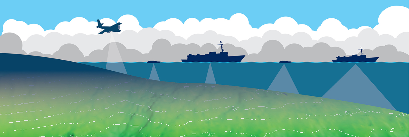
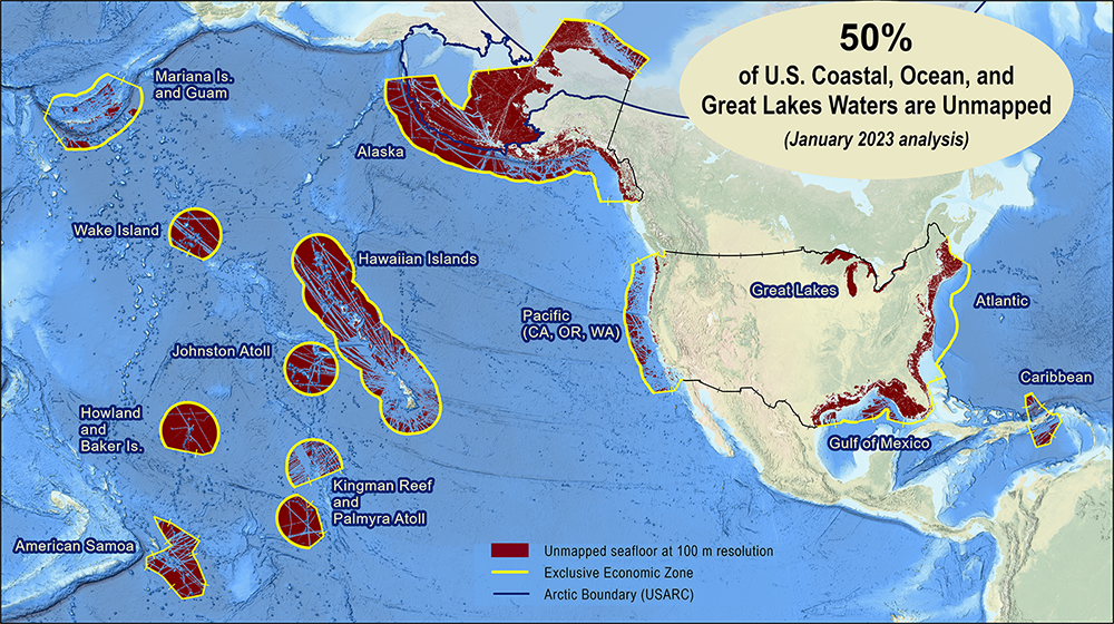
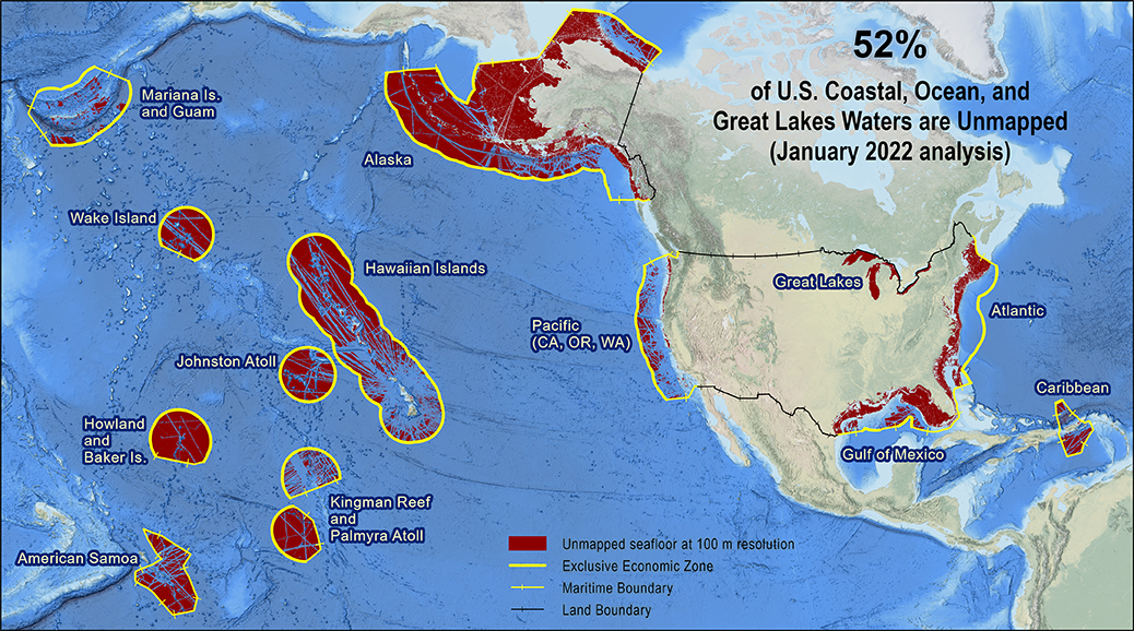
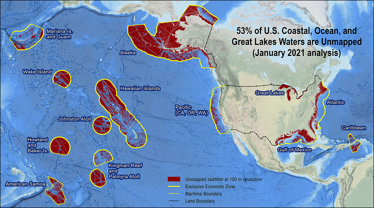
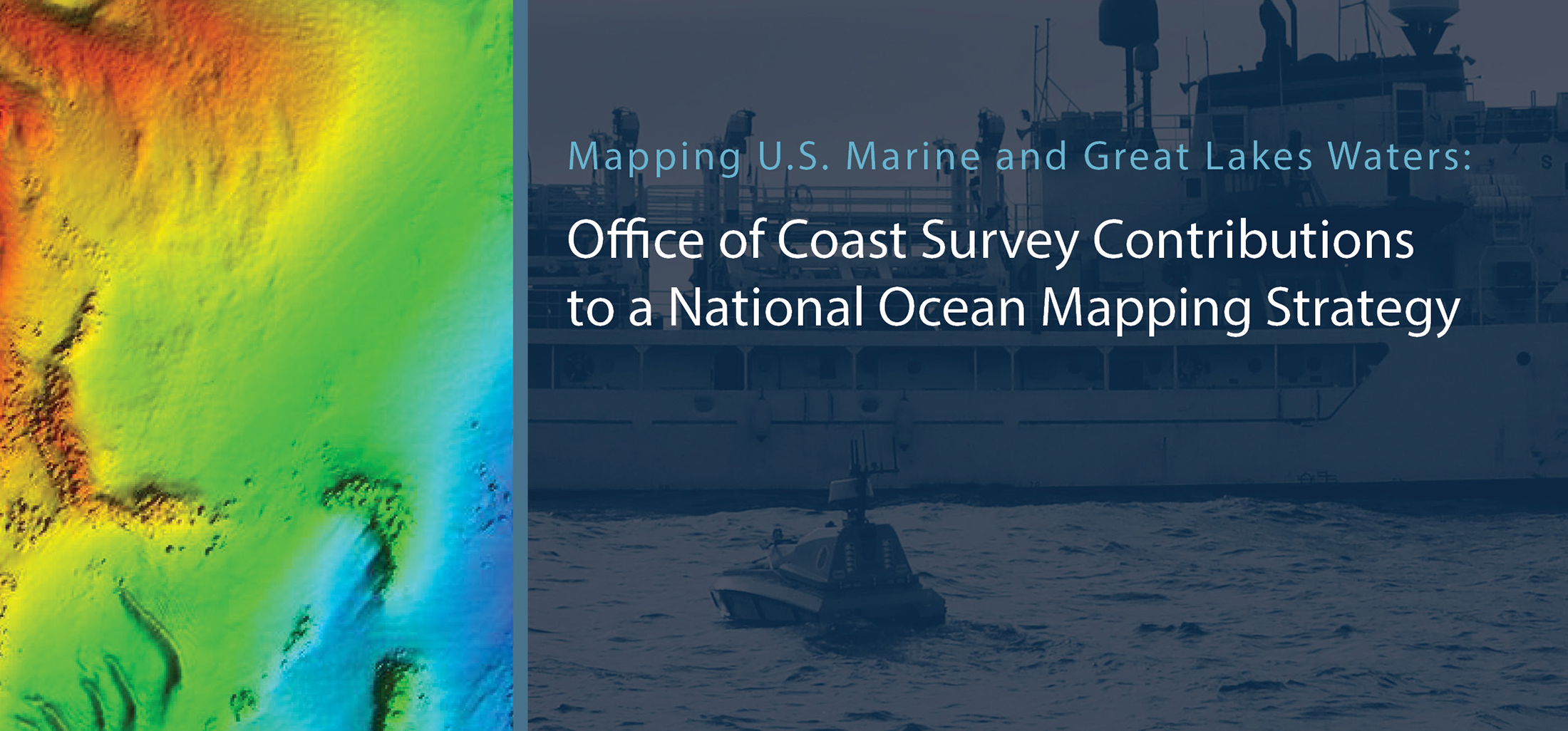
The federal Interagency Working Group on Ocean and Coastal Mapping (IWG-OCM) has released the fourth annual report on progress made in mapping U.S. ocean, coastal, and Great Lakes waters. Knowledge of the depth, shape, and composition of the seafloor has far-reaching benefits, including safer navigation, hazard mitigation for coastal resilience, preservation of marine habitats and heritage, and a deeper understanding of natural resources for sustainable ocean economies. The 2020 National Strategy for Mapping, Exploring, and Characterizing the United States Exclusive Economic Zone (NOMEC) and the Nippon Foundation-GEBCO Seabed 2030 Project make comprehensive ocean mapping a priority for the coming decade. The Unmapped U.S. Waters report tracks progress toward these important goals.

Continue reading “The Interagency Working Group on Ocean and Coastal Mapping announces progress report on mapping U.S. ocean, coastal, and Great Lakes waters”

NOAA contributes to Empowering Women in Hydrography through at-sea experience, part 3

An image of Firosa Tomohamat, from Suriname’s Maritime Authority, sitting on a bench on deck 2 of NOAA Ship Thomas Jefferson.

The Empowering Women in Hydrography project is a global effort led by the International Hydrographic Organization and Canada that seeks to initiate, organize and track a series of activities and initiatives which will enable more women to participate equitably in the field of hydrography and to assume leadership roles within the hydrographic community. NOAA is contributing to the project via an ‘at-sea experience’ on NOAA hydrographic ships for three women each year over the four year lifespan of the project. After a global call for nominations, three women were selected to join NOAA ships for the 2022 survey season. Firosa Tomohamat from Suriname’s Maritime Authority, joined NOAA Ship Thomas Jefferson from August 8 to 26, 2022 while surveying the Great Lakes.

Continue reading “NOAA contributes to Empowering Women in Hydrography through at-sea experience, part 3”

NOAA contributes to Empowering Women in Hydrography through at-sea experience, part 2

NOAA ship Thomas Jefferson from survey launch 2904 at sunrise.

The Empowering Women in Hydrography project is a global effort led by the International Hydrographic Organization and Canada that seeks to initiate, organize and track a series of activities and initiatives which will enable more women to participate equitably in the field of hydrography and to assume leadership roles within the hydrographic community. NOAA is contributing to the project via an ‘at-sea experience’ on NOAA hydrographic ships for three women each year over the four year lifespan of the project. After a global call for nominations, three women were selected to join NOAA ships for the 2022 survey season. Chiaki Okada from the Hydrographic and Oceanographic Department, Japan Coast Guard, joined NOAA Ship Thomas Jefferson from July 25 to August 6, 2022 while surveying the Great Lakes.

Continue reading “NOAA contributes to Empowering Women in Hydrography through at-sea experience, part 2”

NOAA contributes to Empowering Women in Hydrography through at-sea experience, part 1

An image showing all woman officer hydrographers standing in front of NOAA Ship Rainier.

The Empowering Women in Hydrography project is a global effort led by the International Hydrographic Organization and Canada that seeks to initiate, organize, and track a series of activities and initiatives which will enable more women to participate equitably in the field of hydrography and to assume leadership roles within the hydrographic community. NOAA is contributing to the project via an ‘at-sea experience’ on NOAA hydrographic ships for three women each year over the four year lifespan of the project. After a global call for nominations, three women were selected to join NOAA ships for the 2022 survey season. Sub-Lieutenant Mercy Modupe Ogungbamila from the Nigerian Navy joined NOAA Ship Rainier from July 5 to 15, 2022 while surveying from Guam to Saipan.

Continue reading “NOAA contributes to Empowering Women in Hydrography through at-sea experience, part 1”

Coast Survey’s mobile integrated survey team goes to Antarctica

An image of the United States Coast Guard cutter Polar Star docked at McMurdo Station ice pier on a relatively ice free day for Winter Quarters Bay.
By, Annie Raymond

In 1959, following the International Geophysical Year of 1957-58, scientists from twelve nations conducting active research in Antarctica came together and signed the Antarctic Treaty. In the years following, 42 additional countries acceded to the treaty. The treaty preserves the entire continent and surrounding waters solely for purposes of peaceful scientific collaboration and bans resource extraction and military activity. McMurdo Station on Ross Island, operated by the United States through the United States Antarctic Program, a branch of the National Science Foundation (NSF), has emerged as the largest year-round station and primary logistics hub for the region. The first U.S. Operation Deep Freeze happened prior to and in support of the International Geophysical Year of 1957-58. Since then, Operation Deep Freeze has continued annually and has become the name for supply sealift missions to McMurdo, delivering fuel, food, and supplies to scientists in Antarctica.

Continue reading “Coast Survey’s mobile integrated survey team goes to Antarctica”