One year later – Coast Survey’s response to the Anchorage earthquake

Multibeam data acquired by eTrac in Knik Arm, offshore of Anchorage.

By Lt. Cmdr. Bart Buesseler

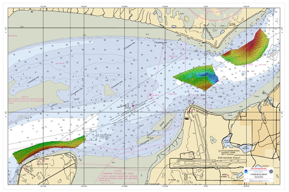
At 8:29, on the morning of Friday, November 30, 2018, a magnitude 7.1 earthquake shook Anchorage, Alaska, for thirty stressful seconds. It was the largest earthquake in Anchorage since the Good Friday Quake of 1964, and brought Alaska’s most populated city to a standstill as residents evacuated buildings and came to terms with what they had just experienced.

Continue reading “One year later – Coast Survey’s response to the Anchorage earthquake”

NOAA Ship Rainier returns to survey the Hawaiian coast, provides update on lava flow development

Rainier collects multibeam sonar data along Puna Coast on the Big Island of Hawaii.

By Ens. Harper Umfress

NOAA Ship Rainier’s four-decade tropical sonar silence is over and Hawaiian hydrography is back! The 2019 field season was productive, challenging, and geographically diverse. After starting the season with traditional hydrographic surveys in Alaska, Rainier was re-tasked to support science diving operations in the Papahānaumokuākea Marine National Monument that surrounds the Northwestern Hawaiian Islands. Though the primary purpose of this dispatch was to support coral reef research, the world’s most productive coastal hydrographic survey platform would have been remiss to forego this opportunity to ping new waters.

Continue reading “NOAA Ship Rainier returns to survey the Hawaiian coast, provides update on lava flow development”

NOAA Ship Thomas Jefferson tests innovative DriX unmanned surface vehicle

Drone photo of the DriX underway from the ship with the DDS still in the water.

By Ens. Taylor Krabiel

During the month of October, NOAA Ship Thomas Jefferson integrated and operated a DriX, an Unmanned Surface Vessel (USV) created by the French technology company iXblue. The primary goal of the project was to test iXblue’s unique deployment and recovery solution specifically designed for Thomas Jefferson’s on board survey launch davit. Survey launches are limited to daylight operations and deployment and recovery are the most challenging operations the ship undertakes. Utilizing a DriX for continuous survey operations without having to recover and/or service it for up to four days straight would significantly increase the ship’s efficiency.

Continue reading “NOAA Ship Thomas Jefferson tests innovative DriX unmanned surface vehicle”

NOAA Ship Nancy Foster performs full-coverage mapping survey of Northern Blake Plateau

ST Barbee and NOAA Affiliate Veronica Martinez deploy Nancy Foster’s Underway CTD.

By Julia Wallace and Lt. j.g. Michelle Levano

NOAA Ship Nancy Foster conducted survey operations offshore of coastal South Carolina from August 12-30, 2019, as a joint effort between NOAA’s Office of Coast Survey and Office of Ocean Exploration and Research. This survey encompassed portions of the Blake Plateau, and was particularly special because this region has never been mapped using contemporary sonar systems. The project served Coast Survey’s mission of providing contemporary data to update nautical charting products and supported the U.S. contribution to Seabed 2030, a multi-national initiative to map the world ocean by 2030. NOAA’s contribution to this project includes providing continuous multibeam survey coverage within the U.S. Exclusive Economic Zone.

Continue reading “NOAA Ship Nancy Foster performs full-coverage mapping survey of Northern Blake Plateau”

NOAA supports safe ferry transit in Puget Sound

NRT-Seattle with the F/V Salish.

By Lt. j.g. Michelle Levano

If you have spent time on the water in Puget Sound, you have probably seen the large, distinct green and white vessels. These vessels move passengers, vehicles, and cargo across Puget Sound to the San Juan Islands and to Victoria, Canada, year round. They are a part of the Washington State Department of Transportation ferry system. The state has been operating ferries since 1951, and intended to run the ferry service until cross Sound bridges could be built.  These bridges were never built, and the state continues to operate the ferries to this day. As of last July, there are 22 state-operated ferries on Puget Sound, with the largest vessel able to carry 2500 passengers and 202 vehicles. 

Continue reading “NOAA supports safe ferry transit in Puget Sound”

Hawaiian island surveys will update nautical charts and support habitat mapping efforts

Three of Rainier’s hydrographic survey launches moored in Kahului Harbor, Maui.

By Ens. Lyle I. Robbins

For more than 50 years, NOAA Ship Rainier and its hydrographic survey launches have surveyed the Pacific seafloor. During this time, Rainier sailed thousands of miles, including the entire U.S. west coast, Alaska, and Hawaii. This year, Rainier expands on its traditional role of hydrographic survey and is supporting dive operations in the Northwest Hawaiian Islands and in the Papahānaumokuākea Marine National Monument. While Rainier is sailing these remote coral atolls, the survey launches — that are usually in its davits and deployed directly from the ship — are tasked to their own surveys around the islands of Maui, Moloka’i, and O’ahu.

Continue reading “Hawaiian island surveys will update nautical charts and support habitat mapping efforts”

NOAA Ship Rainier successfully field tests autonomous hydrographic survey launch

Autonomous survey launch.

By Lt. j.g. Airlie Picket

NOAA Ship Rainier field tested a new hydrographic survey platform this season. Last winter, one of the ship’s hydrographic survey launches was converted into a semi-autonomous vessel, allowing it to be operated remotely.  Hydrographic surveying is, by nature, dangerous. Autonomous systems have the potential to augment traditional surveying methods, improving efficiency and decreasing (or eliminating) risk to the surveyors themselves. As such, this technology is an exciting step toward fully-autonomous hydrographic survey systems.

Continue reading “NOAA Ship Rainier successfully field tests autonomous hydrographic survey launch”

Saildrone launched with seafloor mapping capabilities in the Gulf of Mexico shows promise for remote Arctic mapping

Rear Adm. Shep Smith, Richard Jenkins, and Brian Connon in front of a Saildrone.

NOAA’s Office of Coast Survey, the University of Southern Mississippi (USM), and Saildrone accomplished a key milestone in the research and testing of unmanned technology that can lead to enhanced seafloor mapping capabilities with the launch of the first Saildrone — a wind-driven and solar-powered unmanned surface vehicle (USV) — equipped with multibeam echo sounder technology in the Gulf of Mexico. NOAA anticipates the success of this mission and technical achievement will lead to mapping projects in the Arctic.

Continue reading “Saildrone launched with seafloor mapping capabilities in the Gulf of Mexico shows promise for remote Arctic mapping”

NOAA completes hydrographic surveys following Hurricane Barry

Lt. j.g. Patrick Lawler and Lt. j.g. Michelle Levano remove the side scan sonar from the water.

By Lt. j.g. Michelle Levano

Seven tropical cyclones in the Atlantic Ocean have been named Barry, with the first storm making landfall in 1983. In 2019, Hurricane Barry reached Category 1 status on July 13, becoming the first hurricane of the 2019 season. 

On July 11, Office of Coast Survey’s Gulf Coast Navigation Manager, Tim Osborn, received requests from U.S. Coast Guard, U.S. Army Corps of Engineers, and local ports for resources to confirm navigational depths in Louisiana waters. Once a navigation manager receives requests for hydrographic surveys, Coast Survey formulates logistics to complete these requests. In the case of Hurricane Barry, Coast Survey’s navigation response team (NRT)- Stennis mobilized to respond to Port Fourchon, Louisiana’s southernmost port. Port Fourchon supports significant petroleum industry traffic coming in from the Gulf of Mexico, furnishing about 18% of the U.S. oil supply

Continue reading “NOAA completes hydrographic surveys following Hurricane Barry”