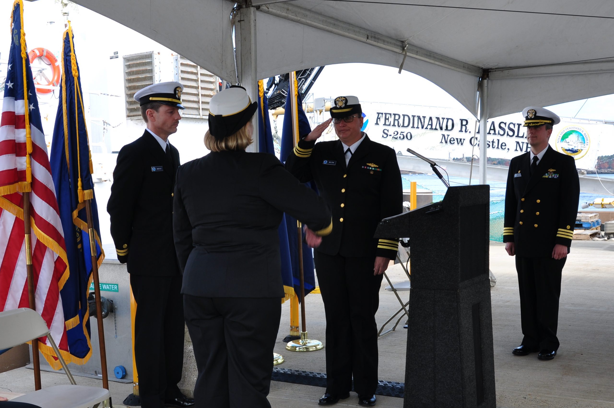
Coast Survey welcomes Guy Funnell from the UK Hydrographic Office

Guy Funnell (left) meets with NOAA-certified print-on-demand chart sub-agent Horizon Nautical.

Hydrographic offices around the world often share expertise and experiences in order to improve products and processes. In that vein, NOAA’s Office of Coast Survey welcomes Guy Funnell, a product manager from the United Kingdom Hydrographic Office who will be working with us in a unique employee exchange.
The exchange will be of immense benefit to Coast Survey, as we continue to explore practices and technologies to improve Coast Survey’s product management.
The UKHO is an equivalent to Coast Survey, but with some major differences. While Coast Survey and the UKHO have a working relationship going back over a century, the UKHO got a jump on us in chart production, producing their first chart (of Quiberon Bay in Brittany) in 1800. We came along a little later, when President Thomas Jefferson signed legislation in 1807, calling for a survey of the coast.
Continue reading “Coast Survey welcomes Guy Funnell from the UK Hydrographic Office”

Coast Survey participates in international Arctic survey project – Part 2

By Edward Owens
In a previous post, Edward shared his initial experience on board the Canadian Coast Guard vessel Louis S. St-Laurent as they traveled from Halifax, Canada, toward Tromsø, Norway. Today, he provides an update as well as a look at some of the features they found on the seafloor along the way.

photo of Edward Owens
Edward Owens on board Canadian Coast Guard vessel Louis S. St-Laurent.

It is a Sunday and our transit across the Atlantic on board Canadian Coast Guard vessel Louis S. St-Laurent  is nearly complete. We’ll arrive in Tromsø, Norway, on Tuesday morning where we’ll rendezvous with a pilot boat to complete the final leg of our internationally coordinated hydrographic mission, as the latest contribution to the Galway Statement on Atlantic Ocean Cooperation.
Continue reading “Coast Survey participates in international Arctic survey project – Part 2”

Coast Survey hosts Hollings Scholar

Valerie in the NOAA Ship Fairweather engine room.
Valerie Rennoll, Coast Survey’s first Hollings Scholar, stands in the NOAA Ship Fairweather engine room.

By, Melissa Volkert
Meet Valerie Rennoll, the Office of Coast Survey’s first Ernest F. Hollings (Hollings) Scholar on a NOAA vessel.
Originally from Glen Rock, Pennsylvania, Valerie discovered the Hollings Scholarship from a professor at American University while working toward her double major in physics and audio technology. She found that the scholarship program aligned well with her interests as she learned of NOAA’s extensive work with underwater acoustics.
Continue reading “Coast Survey hosts Hollings Scholar”

What does the age of the survey mean for nautical charts?

Vintage of Alaska survey

Alaska’s nautical charts need to be updated — we all know that. The diagram below shows the vintage of survey data currently used for today’s charts in Alaska. The graphic includes all surveys done by NOAA’s Office of Coast Survey (and its predecessors), and some limited data acquired by other agencies, i.e., the U.S. Coast Guard. Areas that are not colored in have never been surveyed or have data acquired by another source — from Russia or Japan, for instance — before the U.S. was responsible for charting in that area.
Continue reading “What does the age of the survey mean for nautical charts?”

Coast Survey participates in international Arctic survey project

By Edward Owens

Edward Owens
Coast Survey’s Edward Owens on the Canadian Coast Guard vessel Louis S. St.-Laurent  as it approaches The Narrows near the city of St. John’s.

Hello to all from the Canadian Coast Guard vessel Louis S. St-Laurent (CCG LSSL), affectionately called the ‘Louis.’ She is an impressive 120 m long, 24.5 m wide with a cruising range of 23,000 nautical miles and carries two CCG helicopters. There are 86 cabins with 100 bunks and today she currently sails with 77 souls on board. I’ve gotten lost, turned around, and confused while navigating my way through the labyrinth of neat and tidy stairways, corridors, and doorways on numerous occasions. Luckily, I’m beginning to find my way around thanks to all the artwork and placards mounted on the walls which I’ve depended on as landmarks to help me get where I’m going. Everything is arranged on five main decks. I am berthed on the 300 level or the flight and boat deck conveniently near the acoustics science lab. The galley is three decks down and as long as I can find it, I’ll be just grand.
Continue reading “Coast Survey participates in international Arctic survey project”

NOAA holds international workshop for nautical chart agencies

Workshop participants.
Hydrographers from 11 different countries attended a workshop on nautical chart adequacy in Silver Spring, Maryland.

This week, hydrographers from 11 different countries traveled to Silver Spring, Maryland, to attend a workshop on nautical chart adequacy. Workshop participants included scholar students from the General Bathymetric Chart of the Oceans Organization, and participants from Israel, Malaysia, South Korea and United Kingdom. The workshop, developed and hosted by Coast Survey and the Joint Hydrographic Center, University of New Hampshire, trained the hydrographers on procedures to assess the adequacy of their respective nautical charts using publicly-available information.
Continue reading “NOAA holds international workshop for nautical chart agencies”

Coast Survey attends first meeting of IHO’s Nautical Information Provisions Working Group

Coast Survey’s Tom Loeper and Captain Tetsushi Mitsuya, commanding officer of the training ship Kojima of Japan Coast Guard, attend the IHO event onboard the Kojima.

Coast Survey attended the first meeting of the Nautical Information Provisions Working Group (NIPWG) held at the International Hydrographic Organization in Monaco.
During the meeting, Coast Survey’s Tom Loeper, chief of Navigation Services Division’s Coast Pilot branch and Great Lakes navigation manager, was reappointed as the secretary for the working group, a position he has held for 2 years. Two other working group members from the United States also attended the meeting, Briana Sullivan from the University of New Hampshire, and Mike Kushla from the National Geospatial-Intelligence Agency.
Continue reading “Coast Survey attends first meeting of IHO’s Nautical Information Provisions Working Group”

Coast Survey aids U.S. Coast Guard in recovering sunken buoy

This is a chartlet showing the location as well as measurements of the five different features found through multibeam sonar surveys of the NRT6.

Coast Survey’s Navigation Response Team (NRT) 6 responded to a request from the U.S. Coast Guard to locate and facilitate recovery of a sunken mooring buoy near Sausalito, California.
Although not a threat to surface navigation, there are two reasons for this recovery effort. The first is to protect mariners from getting their anchors caught on the buoy or tangled in the mooring chain. Recovery will also allow the U.S. Coast Guard to repair and possibly reuse the buoy.
Continue reading “Coast Survey aids U.S. Coast Guard in recovering sunken buoy”

NOAA dedicates memorial at Absecon Lighthouse

Sunday, June 21, was World Hydrography Day, a day set aside to recognize the important work of hydrographers.  Measuring and describing the physical features of oceans, seas, and coastal areas is essential not only to the safe navigation of the everyday mariner, but to our nation’s economic development, security and defense, scientific research, and environmental protection.

Absecon lighthouse with NOAA flag
The NOAA flag flies at the Absecon Lighthouse during the memorial dedication. Photo by David Hall

This year’s observation was particularly noteworthy for NOAA, as we honored the lost crew members of the U.S. Coast Survey Steamer Robert J. Walker, by dedicating a memorial at the Absecon Lighthouse in New Jersey.
On June 21, 1860, the Robert J. Walker was hit by a commercial schooner while transiting from Norfolk to New York after months of surveying in the Gulf of Mexico. The ship sank 12 miles offshore, as they were heading to the Absecon Lighthouse after they were hit. Coast Survey lost twenty crew members that night, and another man died from his injuries the next day, in the largest single loss of life in Coast Survey and NOAA history.
Continue reading “NOAA dedicates memorial at Absecon Lighthouse”

Over 35,000 conductivity, temperature, and depth profiles added to public oceanographic database

Well before the invention of the computer and the following onslaught of digital data, S.R. Ranganathan in his 1939 book, “Theory of Library Catalogue,” described in detail how a library catalog should work and be prepared. Since then, the way we develop and maintain information databases and archives has dramatically changed. The format has morphed beyond traditional books and journals to large amounts of digital data.
The Office of Coast Survey alone produces digital data on order of several terabytes a year, and much of this data is collected by NOAA hydrographic survey vessels. In order to make the data easily accessible and available to the public, it is formatted and submitted to the National Center for Environmental Information (NCEI) ocean data archive. Here, the basic principles of library cataloging apply – find the appropriate information quickly and in the location it is supposed to be stored.

Map showing locations of recovered oceanographic profiles
Locations of recovered oceanographic profiles.

Continue reading “Over 35,000 conductivity, temperature, and depth profiles added to public oceanographic database”