Coast Survey helps communities prepare for the 2015 Atlantic hurricane season

Public preparedness meeting at Port Morgan City, Louisiana.

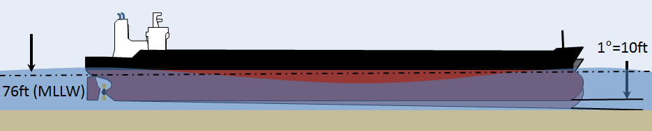
June 1 marks the beginning of the 2015 Atlantic hurricane season. Although NOAA projects it to be a below normal season, it doesn’t mean coastal areas will have it easy. In the wake of a hurricane, Coast Survey plays a critical role in NOAA’s response efforts. But what about before the storm? In addition to building relationships and coordinating emergency response capabilities with agencies such as  U.S. Coast Guard, U.S. Army Corps of Engineers, and port authorities, Coast Survey focuses on local community preparedness meetings and outreach events throughout the month of May.
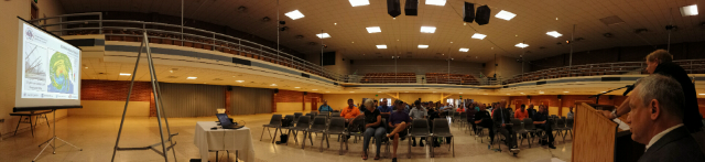
Recently, Coast Survey’s navigation manager for the central Gulf Coast, in partnership with The National Weather Service Lake Charles and the Port of Morgan City, Louisiana, conducted public preparedness forums in Lafayette, Lake Charles, and Morgan City. One meeting featured U.S. Representative Charles W. Boustany, Jr., as the speaker. Approximately 90 people attended, including the congressman’s constituents, and local, state, and federal agencies and responders. The information provided was of vital interest given the upcoming start of hurricane season and the 10th anniversary of hurricanes Katrina and Rita.
Continue reading “Coast Survey helps communities prepare for the 2015 Atlantic hurricane season”

All aboard! NOAA’s Bay Hydro II opens its doors to the public at the Port of Baltimore’s National Maritime Day Event

Matt Carter, Survey Technician, answers questions about surveying and charting aboard the Bay Hydro II.

What better way to recognize National Maritime Day than to spend a day at the Port of Baltimore talking with the public about NOAA’s hydrographic survey work.  Coast Survey’s research vessel Bay Hydro II, moored at pier 13 Canton Marine Terminal across from the NS Savannah, participated in the Port of Baltimore’s National Maritime Day celebration on Sunday, May 17.
A great cross-section of visitors came on board throughout the day. From students and families with small children to retired Navy sonar operators, there was no shortage of enthusiastic people to talk to.
Continue reading “All aboard! NOAA’s Bay Hydro II opens its doors to the public at the Port of Baltimore’s National Maritime Day Event”

Coast Survey improves the U.S. Coast Pilot by providing geotags

The U.S. Coast Pilot, the supplement to raster navigational charts (NOAA RNC®) and electronic navigational charts (NOAA ENC®), now provides geotagged reference points. A geotag is simply geographical location information assigned to a type of media. In this case, a geotag conveniently assists mariners with landmark positions and displays the associated nautical chart inset in the HTML version of Coast Pilot. Currently, 75 percent of the nine Coast Pilot volumes have been geotagged, with more points available each week to the mariner. Coast Pilot is updated and available for download weekly, and can easily be used on mobile devices such as smart phones and tablets. To access the geotags, select a Coast Pilot book and click the HTML hyperlink adjacent to each individual chapter of the book.

Access to the HTML version of Coast Pilot, where the geotags are located, can be found within each Coast Pilot Book webpage.  This image shows the location of the HTML link for Coast Pilot Book 2.
Access to the HTML version of Coast Pilot, where the geotags are located, can be found within each Coast Pilot Book webpage. This image shows the location of the HTML link for Coast Pilot Book 2.

Continue reading “Coast Survey improves the U.S. Coast Pilot by providing geotags”

Coast Survey assists pilots in efforts to “see” dredging operations on laptop displays

What do pilots see on the navigation laptop displays of their portable pilot units (PPUs) when they guide deep-draft ships to dock? Often, they aren’t seeing all that is actually out there in the navigation channel.
NOAA Coast Survey’s navigation manager Tim Osborn recently observed the problem when he accompanied one of the pilots from the New Orleans Baton Rouge Pilots Association in a ship transit on the Mississippi River.
Continue reading “Coast Survey assists pilots in efforts to “see” dredging operations on laptop displays”

Coast Survey helps scientists sharpen hydrographic skills

NOAA hydro class at USCG Training Center

By Lt.j.g. Eric Younkin
For four weeks in February, NOAA’s Office of Coast Survey offers formal hydrographic training to newly hired survey technicians and physical scientists, using the beautiful campus at the United States Coast Guard Training Center in Yorktown, Virginia. This year, dozens of NOAA employees and others took the extensive training, covering everything from acoustics and statistics to the processing of hydrographic survey data within the CARIS software package.
Two dozen people attended in person. They came from a wide range of duty assignments: NOAA ships Rainier, Fairweather, Thomas Jefferson, Pisces, and Oscar Dyson; Coast Survey’s R/V Bay Hydro II, Navigation Response Team 1, and the Atlantic Hydrographic Branch; NOAA’s National Geospatial Data Center; and the Washington State Energy Office. In addition, we had “virtual” attendance from the NOAA ships as well as from the Olympic Coast National Marine Sanctuary, the Integrated Ocean and Coastal Mapping Center, Washington State Energy Office, and United States Coast Guard District 17.
Continue reading “Coast Survey helps scientists sharpen hydrographic skills”

Developing products for “precision navigation”

ship clearance at 1 degree pitch

Ports of Los Angeles and Long Beach are first up

by Capt. Richard Brennan, chief, Coast Survey Development Lab
The increased size of vessels entering U. S. ports, coupled with the diminishing margins that must be navigated with reference to the seafloor, provides NOAA with the opportunity to develop new products to support precision navigation. The ports of Los Angeles and Long Beach are testing grounds for current product development, since developing products for these ports will allow us to examine the value of precision navigation products under actual at-sea conditions. The channel leading to the Port of Long Beach has an authorized depth of 76 feet, allowing drafts of 69 feet. A major concern for this port is high sea swell conditions that can be present when ultra large crude carriers enter port. These large swells can cause vessels to pitch, which results in a significant change in their draft.
Continue reading “Developing products for “precision navigation””

Coast Survey announces plans for 2015 NOAA survey projects

2015 survey plan outlines

In 2015, NOAA survey ships Thomas Jefferson and Ferdinand R. Hassler are scheduled to survey nearly 1,800 square nautical miles in the U.S. coastal waters of the lower 48 states, collecting data that will update nautical charts for navigation and other uses. In Alaska, NOAA ships Fairweather and Rainier will increase their Arctic operations, planning to acquire 12,000 nautical miles of “trackline” depth measurements of the U.S. Coast Guard’s proposed shipping route. (See this NOAA article.) The ships will also conduct several “full bottom” hydrographic survey projects, acquiring data from over 2,800 square nautical miles in survey areas along the Alaskan coastline.
We are also planning several projects for our contractual private sector survey partners, and those projects will be announced after work orders are finalized.
Continue reading “Coast Survey announces plans for 2015 NOAA survey projects”

Explore once, use many times

OE Survey W00286

This post is adapted from a poster at the U.S. Hydro 2015 conference, in National Harbor, Maryland.

Pilot project shows nautical charting applications using NOAA Ship Okeanos Explorer data

By
James J. Miller and Tyanne Faulkes, physical scientists, NOAA Office of Coast Survey, Atlantic Hydrographic Branch
Lindsay McKenna, physical scientist, ERT Inc. contractor with the NOAA Office of Ocean Exploration and Research
Mapping is the foundation of ocean exploration and marine spatial planning. In its mission to explore and broaden our knowledge of the oceans, the NOAA Ship Okeanos Explorer has collected high-resolution multibeam data as an integral part of its operations around the globe. Since 2013, the Office of Coast Survey has collaborated with the Okeanos Explorer during their expeditions, to improve hydrographic acquisition and processing methods and expand multibeam coverage in the Gulf of Mexico and Atlantic Ocean. The resulting bathymetry has supported a diverse array of oceanic research and contributed to the protection of ecologically critical habitats in U.S. waters.
Continue reading “Explore once, use many times”

NOAA hydro officers honored

Megan Guberski

Each year, the NOAA Association of Commissioned Officers recognizes NOAA Corps officers for their extraordinary accomplishments and contributions. This year, three of the four awards went to officers supporting Coast Survey’s hydrographic program. Congratulations to the officers honored with Junior Officer of the Year, Engineering, and Science awards. Coast Survey applauds your accomplishments!
Continue reading “NOAA hydro officers honored”