An
official website of the United States government.
Here's how you know we're official.
An
official website of the United States government.
Here's how you know we're official.
An
official website of the United States government.
Here's how you know we're official.
An
official website of the United States government.
Here's how you know we're official.
Coastal Oceanographic Forecast Systems (OFS)
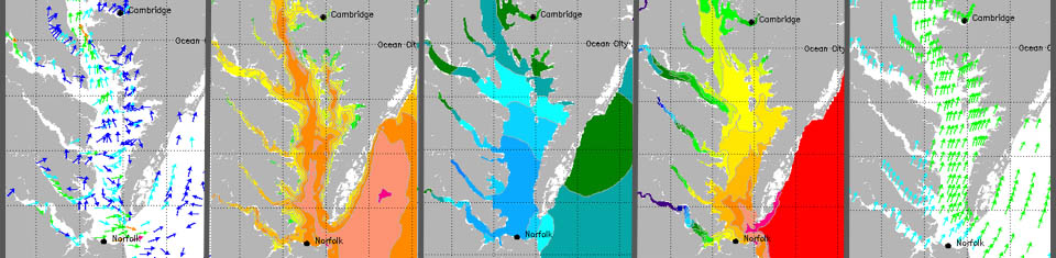
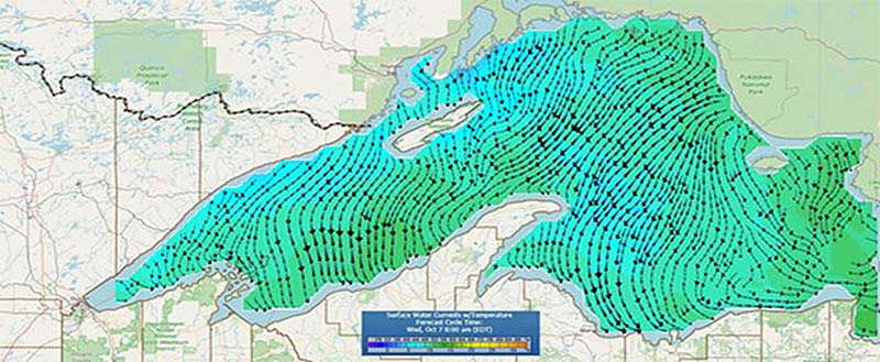
Coast Survey develops, tests, and implements advanced numerical oceanographic forecast modeling systems to provide operational forecast guidance of ocean conditions for coastal waters and the Great Lakes. The work on the coastal ocean models for the Nation is collaborative across NOAA, academia, and private industry. Operational forecast systems (OFS) provide information on tidal and non-tidal sea level variations, as well as currents, temperature, and salinity, in three dimensions. These variables can provide guidance to ship operators for route planning (i.e. avoiding strong opposing currents to save fuel) and route monitoring (safe and efficient coastal navigation, i.e. avoiding low water levels and grounding risks). This navigation guidance is part of the NOS Precision Navigation initiative, which aims to integrate important data streams into single-dissemination, so that mariners can make decisions driven by data. Coast Survey's modeling team works collaboratively with the community to develop and operate models that align with the vision, strategy, and implementation plan of the National Ocean Service (NOS).
NOS's coastal models were historically developed for local and regional geographic extents; Coast Survey is now working towards a streamlined approach to provide nationwide prediction capabilities by supporting an efficient combination of basin-, ocean-, and global-scale models. These advanced models are especially designed to predict conditions for U.S. coastal waters with high resolution and accuracy. These systems are based on open-source, community-supported numerical ocean models, such as: ADvanced CIRCulation Model (ADCIRC), the Semi-implicit Cross-scale Hydroscience Integrated System Model (SCHISM), the Finite Volume Community Ocean Model (FVCOM), and the Regional Ocean Modeling System (ROMS).
Coast Survey has developed a framework through which timely, actionable coastal intelligence information is provided to support navigation, commerce, and safety. The pillars of this framework are being useful, usable, and used. Coast Survey has developed specific models and tools for these goals:
Useful: Coast Survey develops and operates the Surge and Tide Operational Forecast System (STOFS), a coastal ocean prediction system that provides forecast guidance of total water level, water currents, salinity and water temperature. Development of STOFS is collaborative and community-driven to address user requirements. Two community models are used in STOFS, ADCIRC and SCHISM, and collaborative partnerships with the model developers in academia have been critical. STOFS has modeling components at basin, ocean and global scales to best represent oceanic physical processes and to ultimately resolve accurate coastal ocean conditions nationwide for the United States. Coast Survey also utilizes regional- and basin-scale models that support data assimilation in order to provide more accurate prediction on the continental shelf and across the Exclusive Economic Zone.
Usable: Coast Survey's real-time coastal ocean models are designed to be an integral part of NOAA's Unified Forecast System (UFS), a community-based, coupled, comprehensive Earth modeling system. To accomplish this, we work collaboratively across NOAA and the community to ensure that the models are compliant with UFS requirements to enable the exchange of information across modeling domains. In this manner, coastal ocean models like STOFS have the ability to work in conjunction with other models in NOAA such as those for hydrology, atmosphere, waves, sea ice, and more. Coast Survey also works across NOS to develop VDatum, NOAA's vertical datum transformation tool. VDatum is fundamental to ensuring that users of NOAA models in the coastal zone can properly reference the bathymetry and elevation information across different regions and between the many types of vertical datums in the U.S. This is critical to situations such as ships having information referenced to chart datum, so they can safely navigate to U.S. ports. Precision navigation is also dependent on modern real-time systems onboard ships to monitor the dynamically changing water conditions. To facilitate the use of coastal models in these systems, Coast Survey develops tools to format the model outputs into files that can be used by these real-time instruments on the ships.
Used: Dissemination of the model results is critical to the information being accessible and used. Coast Survey develops and operates nowCOAST, a web mapping portal for access to a wide range of NOAA models and data. nowCOAST provides present and future oceanographic, meteorological, and hydrologic information (observations, analyses, forecasts, alerts) from NOAA along with bathymetric data for U.S. coastal areas to support public safety, coastal preparedness, response, and precision marine navigation.