
By Jack Riley and Sergey Vinogradov, Ph.D.
The Pacific Ocean is the largest and deepest of Earth’s oceanic divisions. It extends from the Arctic Ocean in the north to the Southern Ocean in the south and is bound by the continents of Asia and Australia in the west and the Americas in the east. Most of the U.S. Pacific territories are located in the northern half of the Pacific Ocean and are among the Pacific Islands that are highly exposed to natural disasters. As part of NOAA’s coastal resilience efforts, the National Ocean Service (NOS) is developing better tools to define changes in water level related to tropical cyclones and other weather related conditions. This work is part of the global effort to develop disaster risk assessment tools and practical technical applications to reduce and mitigate coastal countries’ vulnerability to natural disasters.
A new two-year project addresses the shortfall in NOAA’s current products and services in the Pacific Ocean. This coordinated effort among NOS chief scientists and technical directors includes the following research activities:
- Data assimilation of water level observations from tide stations, buoys, and satellite altimetry to develop tide models and datums in the new North American-Pacific Geopotential Datum of 2022 (NAPGD2022).
- Updating NOAA’s vertical transformation tool (VDatum) for regional coverage grids for the Pacific Ocean.
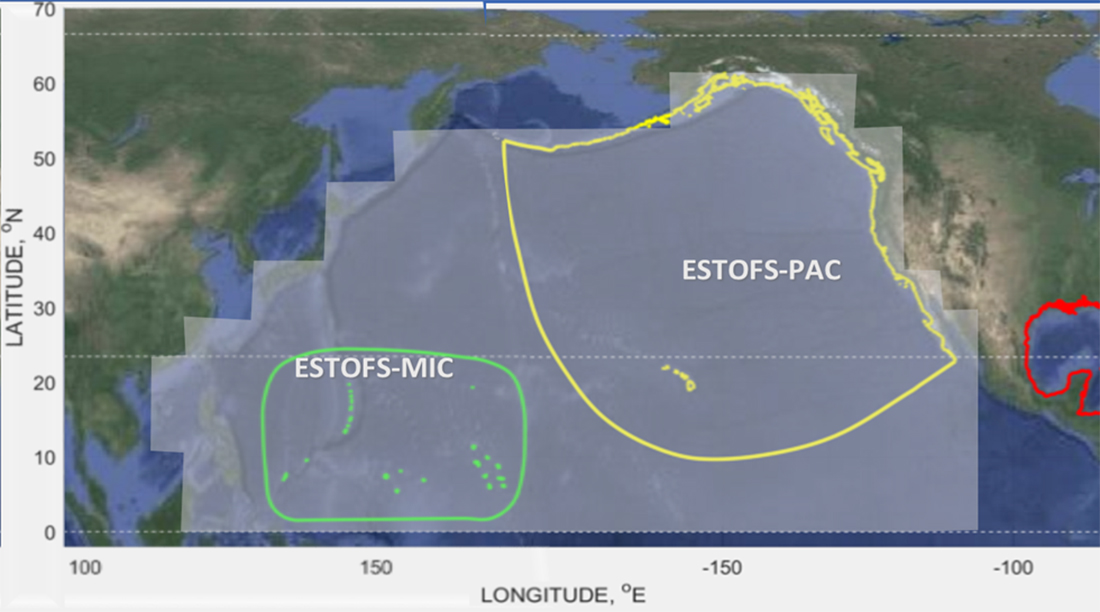
- Using compiled shoreline and bathymetry data, and an improved regional water level forecast model known as Extratropical Surge and Tide Operational Forecast System (ESTOFS).

As a first step in this project, the storm surge and VDatum representatives from NOAA’s Office of Coast Survey, Sergey Vinogradov and Jack Riley, attended their first stakeholder engagement and collection of user requirements for the project’s operational models. The visit included participation in the 2020 Pacific Risk Management ‘Ohana (PRiMO) conference and meeting with regional directors from the National Geodetic Survey and National Weather Service. In addition, they engaged with the University of Hawaii’s Joint Institute for Marine and Atmospheric Research and the Navy’s Joint Typhoon Warning Center. The PRiMO conference is considered the premier venue for community leaders interested in protecting Pacific Island communities from natural hazards. The goals of stakeholder engagement and collection of user requirements meetings were to inform the Pacific end-user community on the status of VDatum and storm surge models, including the new operational global ESTOFS scheduled for this fall, and the enhancements planned for the next two years. NOS plans a follow-up visit this summer.
The outcomes of this new two-year project will lay the infrastructure to reference hydrographic surveying and ocean modeling products to the new National Spatial Reference System. In addition, the improved ESTOFS and VDatum will allow seamless coverage of water level conditions between tropical areas and areas in extratropical latitudes in the Pacific Ocean. These new products will improve communication and collaboration with other international agencies by understanding charting, bathymetry, water level, currents, and other products that NOAA produces. Such effort will also support products and services that are vital for safe maritime navigation, world class geodetic infrastructure, and sustainable use of ocean resources for economic health and growth. The outcomes of this project for the Pacific community are tools to support preparation and planning for accelerating rates of sea-level rise and storm surge that threaten the Pacific Islands.
NOAA’s Office of Coast Survey develops and tests hydrodynamic modeling applications for use in operational systems and products. These include: three-dimensional operational forecast systems to support safe navigation mission requirements, tide models and tidal datum products used in NOAA’s VDatum vertical datum transformation software, and storm surge models to provide combined tide and storm-induced surge guidance for coastal water levels and inundation.