An
official website of the United States government.
Here's how you know we're official.
An
official website of the United States government.
Here's how you know we're official.
An
official website of the United States government.
Here's how you know we're official.
An
official website of the United States government.
Here's how you know we're official.
VDatum
Vertical Datum Transformation, or VDatum, is a tool that converts elevation data from various sources into a common reference system. It is developed jointly by NOAA's National Geodetic Survey, the Office of Coast Survey, and the Center for Operational Oceanographic Products and Services.
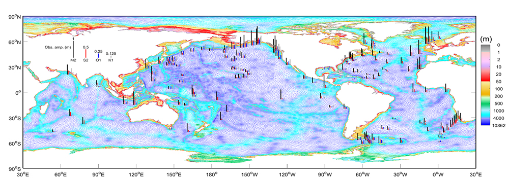
In support of the VDatum tool, Coast Survey develops numerical tide models and tidal datum products for U.S. coastal waters. VDatum is designed to vertically transform geospatial data among a variety of vertical datums. These transformations allow users to convert their data from different vertical references into a common system, thereby enabling the fusion of diverse geospatial data, particularly in coastal regions between bathymetry in chart datum and topography in Mean Sea Level.
The VDatum team develops regional VDatum updates, specifically working on the tidal datum transformations that are made available in the VDatum software. OCS modeling simulates tides in regional applications using ADvanced CIRCulation model (ADCIRC), a coastal hydrodynamic model, to compute spatially varying tidal components for the vertical datum transformation. These model outputs are further combined with tidal observations so that the final VDatum vertical datum transformations are consistent with the published tidal datums made available by CO-OPS. Data assimilation techniques are used to blend the model- and observation-derived tidal datums that will allow VDatum to provide an associated spatially varying uncertainty in the near future.